Flood control project keeps Fairbanks dry
MOOSE CREEK DAM — For the thirteenth consecutive day, four plates of steel in a framework of concrete have quietly saved Fairbanks.
Heavy rains in the basin of the Chena River, the waterway that spawned Fairbanks, have swelled the river to where motorboats can’t squeeze beneath downtown bridges.
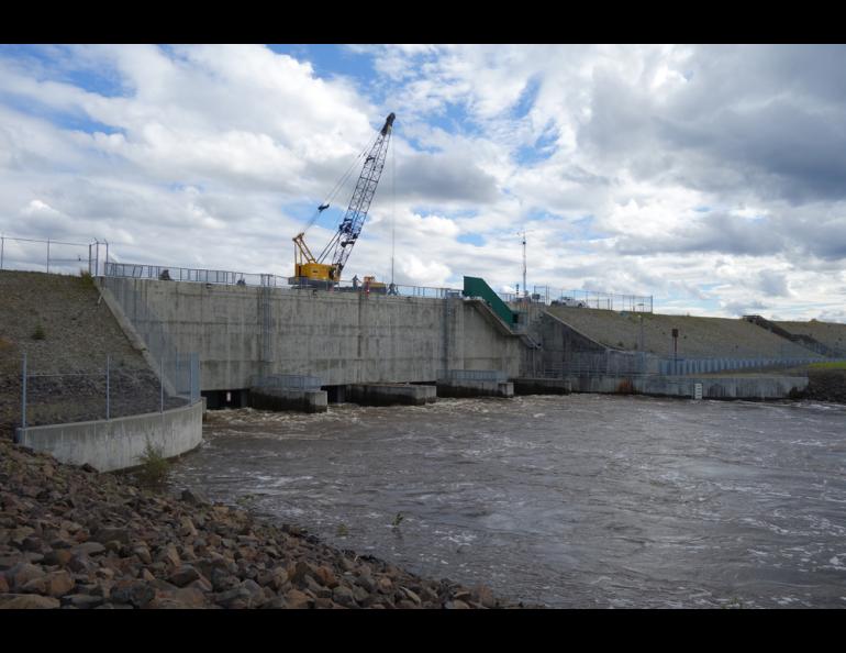
Dam-tenders here have responded by lowering steel gates into the river. The gates skim river water, backing it into an immense channel perpendicular to the river. A 50-foot mound of rock dam reaches eight miles downhill to the larger Tanana River.
In extreme flood conditions, a portion of the Chena here, 40 miles from downtown Fairbanks, can bypass the city and flow into the Tanana. That has only happed once, during a rapid snowmelt in spring 1992. Today, about one fifth of the grassy floodway is a lake five feet deep.
Tim Feavel, project manager for the Chena River Lakes Flood Control Project, has driven me to the top of the concrete shell of the dam called the control works. We can hear the roar of water in ferocious eddies just downstream of the floodgates. The upstream side of the four ports is quieter, with the hiss of river water flowing through spruce and birch logs mashed against the concrete.
“This is the 25th time we’ve lowered the floodgates,” Feavel said. Fairbanks has been spared that many times since the dam was finished in 1979. Judging by $212 million to build the dam, Feavel figures the mortgage was paid off in 2003. And the project increases in value with each prevented flood.
Sue Mitchell, my boss and the editor of these columns, remembers the event that inspired the construction of the Chena River Lakes Flood Control Project. From Aug. 8 to 15, 1967, about seven inches of rain fell in the upper Chena River drainage near the hot springs.
“It ruined my birthday,” she said, remembering how the Fairbanks flood of 1967 turned the city core into a lake that included the park called Alaskaland where she was to have her party. Because her family lived on higher ground north of the University, they hosted another family that wasn’t as lucky.
The 1967 flood destroyed much of Fairbanks and inspired the Army Corps of Engineers to come up with a solution. To create the eight-mile earthen dam, engineers used rock from nearby Brown’s Hill Quarry and an even closer site for gravel. The pits from the gravel are now a chain of lakes where people swim and sunbathe. On the main channel of the Chena, the builders constructed the concrete control works with four bays.
The dam, recreation area and floodplain take up a good chunk of Interior Alaska just south of North Pole. Feavel and six other Corps of Engineers employees work there.
“It’s like managing a 20,000-acre ranch with 20 head of moose,” Feavel said.
The floodgates within the dam are usually hidden in the up position. But when river flow hits 8,000 cubic feet per second at a gauge attached to the downstream wall of the dam, tenders lower the panels and start skimming off the Chena.
When I visited, the gates were lowered to within five feet of the river bottom. Feavel figured the river was about 18 feet deep on the upriver side of the dam and 12 feet deep on the downriver side.
With rains continuing in a somewhat predictable August pattern, Feavel did not know when he and others could raise the floodgates and let the river flow on uninterrupted. But he can drive through town and think about what’s going on 40 twisty miles upstream.
“When people of Fairbanks see the river ripping through town at a high level, they know it won’t get any higher,” he said. “We’re trying to keep it from their front door.”