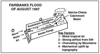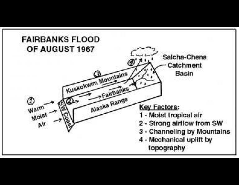
Cause of the 1967 Fairbanks Flood
Normal June rainfall in Fairbanks is 1.39 inches; June 1967 was slightly drier, 1.10 inches, in consequence of relatively dry air moving northward over the Chugach and Alaska Ranges into interior Alaska.
However, in July 1967 there developed a low north of Alaska and a high in the North Pacific. These combined to create increasing flow of moist ocean air from the southwest so that Fairbanks received 3.34 inches of rain instead of the normal 1.84 inches.
In early August 1967 large-scale pressure patterns developed to enhance the flow of air from the southwest and an inflow of Arctic air from the northwest into northern Alaska. A few days before the flood there occurred a strong movement of warm, moist air into the northwest Pacific from a decaying tropical circulation pattern. This air mass evidently was the real source of the water that created the flood. By August 12, 1967, pressure patterns over Alaska were forcing this wet air toward the northeast through the channel formed between the Alaska Range and the paralleling Kuskokwim Mountains. An increasing depth of saturated air built up over the Alaska Range-Kuskokwim channel as the winds from the southwest persisted. Partially blocking the channel at its northeast end is the Yukon-Tanana upland and the White Mountains--the catchment basin of the Chena, Little Chena and Salcha Rivers.
Continuing pressure on the saturated air mass forced it to rise up over the catchment basin . The associated cooling from the uplift was the final physical process required to produce the heavy rainfall of August 11, 12, and 13. In the 24 hours prior to noon August 12, 3.42 inches of rain fell at Fairbanks, by far the highest ever recorded here. Whereas 2.20 inches of rainfall is normal for the month of August, 6.20 inches fell in August 1967.
(This article based on work of N. A. Streten.)