The Seismology and Geodesy group pursues a wide range of disciplines with both global and local significance. We study earthquakes, tsunamis, earth structure, and active tectonics, as well as non-traditional sources of seismicity including nuclear explosions, glaciers, volcanoes, and landslides. We contribute to research topics with global relevance by leveraging the rich tectonics of Alaska, long records of instrumental recordings across the state, and the high-performance computing resources of the Geophysical Institute.
The Alaska Earthquake Center is embedded within the Seismology and Geodesy group and carries out Alaska’s earthquake monitoring mission. This includes operating a 250 station seismic network, research on specific earthquake and tsunami hazards, and an extensive public engagement campaign to help improve Alaska’s earthquake readiness. As a University Affiliated Research Center with the Department of Defense, the group pursues a wide range of R&D and operational missions to assess potential nuclear activities worldwide.
For information about being a student in our program, check out the prospective students webpage. For postdoctoral opportunities it is best to contact faculty of interest directly.
To learn more about what we do and why, check out the following video overview of our group:
Research Areas
- Computational Seismology
- Crustal Deformation
- Earthquake Early Warning
- Earthquake Monitoring
- Ground Motion
- Nuclear Monitoring
- Seismic Source Characterization
- Tsunami Modeling
- Volcano Seismology/Infrasound

Modeling seismic wave propagation is a fundamental component of seismology. This modeling benefits from an accurate characterization of both the source of the waves (e.g., an earthquake) and the complex subsurface structure of the Earth. By using high-performance computing—namely lots of computers in parallel having fast connectivity—we can more accurately model the seismic wavefield. These wavefield simulations produce synthetic seismograms that can be compared with recorded seismograms, allowing us to examine differences that help us improve our representations of earthquake sources and the Earth’s structure. A fundamental goal of improving the characterization of the Earth’s subsurface structure addresses two objectives: 1) improved ground motion predictions for seismic hazard estimation, 2) improved images to guide interpretations of tectonic history, active tectonics, and geodynamics.
Contact: Carl Tape

As tectonic plates move, stresses at the boundaries cause deformation of the Earth’s surface. This energy, stored over long times, is rapidly released in earthquakes. We use geodetic observations, such as Global Navigation Satellite Systems (GNSS, which includes GPS) and Satellite Radar Observations (InSAR) to measure the deformation between and during large earthquakes. These measurements help us to identify segments of the fault that are not continuously sliding as two plates move past one another, which means that these locations may generate an earthquake in the future. Following large earthquakes, we can map the observed deformation at the surface to segmented slip on the fault. From this we can identify how much energy was released during the earthquake and in which locations during the earthquake. Conversely, we can learn which places still store energy to be released in future earthquakes, informing hazard assessments.
Contact: Ronni Grapenthin
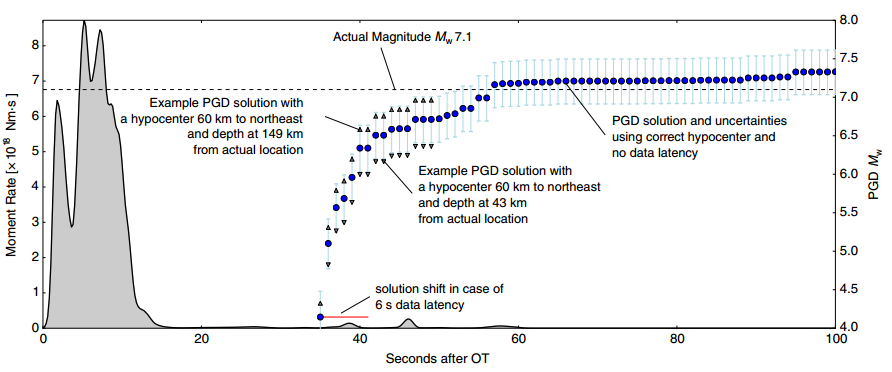
While we are able to identify regions that are at risk of an earthquake and assess the probability of an earthquake on decades-long time scales, we cannot exactly forecast when and where an earthquake will occur. What we can do is exploit the physics of earthquakes, which generate several different kinds of waves. The fastest wave is the P wave, which is a pressure pulse that does not shake the ground very much. The secondary wave, or S wave, travels somewhat slower than the P wave and propagates in a shearing fashion, inducing the shaking that causes the most destruction and destroys infrastructure that can cause fires and other secondary earthquake hazards. Earthquake early warning comes in different forms, depending on what the targets are that require protection. The most common way is to monitor a network of seismometers for P wave detections, attempt to determine location, size and time of the event, and warn regions with high expected shaking before the S wave arrives. For very large earthquakes, GNSS observations are incorporated to improve data on the size of the event and determine how much the fault has slipped, which improves accuracy of shaking forecasts.
Contacts: Ronni Grapenthin, Michael West
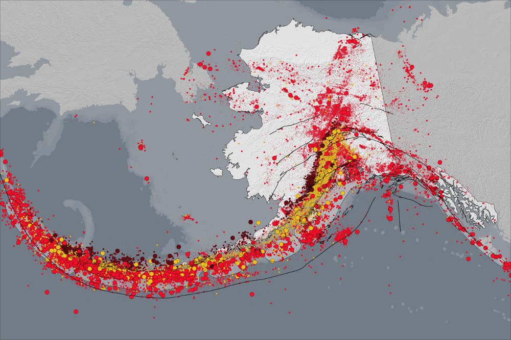
The majority of seismic monitoring stations in the state are operated by our group and we are involved in the oversight of much of the geodetic instrumentation. Together these form the backbone of earthquake monitoring and earthquake hazard assessment in Alaska—a region that comprises most of the largest earthquakes in the U.S. Everyone in the group contributes to this effort whether they are modeling earthquake sources, refining location techniques, or responding to earthquakes in real-time at 3 a.m. Our group includes specialists in every aspect of earthquake monitoring from engineering and data analysis to research and public communication. We are Alaska’s one-stop shop for earthquake info.
Contacts: Michael West, Carl Tape, Ronni Grapenthin

Earthquakes are only as damaging as the ground motions they create. Our group works on several long term projects devoted to measuring and predicting the motion of the ground in critical locations during major earthquakes. Rapid estimates of shaking are used by federal partners, including the USGS and FEMA, to forecast damage and casualties in the minutes after a major quake. Closer to home, these ground motion estimates are used by utility companies, emergency managers, building owners, and the military to know whether or not an earthquake has exceeded design specifics, and whether or not a facility should be treated as compromised. Our efforts to assess ground motion include an extensive strong motion network, wavefield modeling, and increasingly, ground motion data derived from GNSS.
Contact: Michael West

The group is engaged in several projects focused on improving capabilities for detecting and analyzing nuclear events. The GI is home to the nation’s newest University Affiliated Research Center (UARC) specializing in the Geophysical Detection of Nuclear Proliferation (GDNP). The UARC’s mission is to address the strategic gaps in the geophysical detection of nuclear proliferation through acoustic and seismic research and development, testing and evaluation, and related applications for national security.

A seismometer on the Earth's surface records a wide range of events in addition to earthquakes, such as the continuous low-level oscillations of the Earth, a calving iceberg from a glacier, a volcanic eruption, and nuclear explosions. One of our group’s central efforts involves estimating source mechanisms from regional events, such as earthquakes in Alaska or a nuclear explosion from North Korea. We represent these sources as seismic moment tensors, which provide insights into how the faulting of an earthquake occurred. We also emphasize the importance of uncertainty quantification, which is particularly important for characterizing small events, where the recorded signals barely exceed the noise levels. Alaska is a rich place for diverse, frequent earthquakes, and all members of the group have an opportunity to illuminate something fundamental about the latest earthquake in Alaska.
Contacts: Carl Tape, Michael West
Numerous tsunamis have buffeted Alaska’s coast; arrival of the next is only a matter of time. Our group studies the origins of historical tsunamis and considers various possible sources for future tsunami events. We focus on tsunamigenic earthquakes beneath the ocean floor as well as landslides which can occur in coastal fjords. We model, study, and analyze tsunami dynamics from their origination in the open ocean to coastal impacts and share this information with the public to aid in planning for emergency response. We constantly strive to improve our understanding of tsunami sources and modeling techniques by working with many state and federal partners.
Contact: Dmitry Nicolsky
When a volcano erupts it releases seismic energy into the ground and acoustic energy (sound) into the air. GI researchers use low frequency sound, or infrasound, to study and monitor volcanic eruptions in Alaska and around the world. Infrasound provides valuable information on eruption dynamics and can be used to detect, locate, characterize and quantify eruptive activity. Researchers also use infrasound to determine the amount of ash and gas released during an eruption by combining output from numerical models with other measurements, such as gas and seismicity. The group maintains considerable collaborations with the GI Volcanology group.
Contact: David Fee
Project Highlights
Rapid Ground Motion Characterization with GNSS
Global Navigation Satellite Systems (GNSS, including GPS) have long been used to precisely measure positions on the ground before and after large earthquakes. This information is used to determine where and how much the fault slipped. Instead of using positions to characterize earthquakes, we are assessing the potential of using ground velocities, which have the benefit of being available more quickly while being very precise (but lacking information on the absolute position). We aim to analyze all globally available GNSS data from recent large earthquakes and determine how much information about these events the technique will yield. We also analyze the full western (including Alaska) continuous high rate GNSS data during times of no earthquakes to investigate noise characteristics of the time series, and potentially detect earthquakes that are very far away. We hope the outcomes from this NASA-supported work will improve our ability to rapidly characterize large earthquakes and use this information in early warning applications.
Contact: Ronni Grapenthin
Arctic Observing Network
This large-scale initiative, supported by the National Science Foundation, is tracking Arctic change through a combination of geophysical and meteorological observations. The foundation for this project is a network of 45 long-term monitoring sites across northern and western Alaska adapted from the sunsetting Earthscope program. As the Arctic evolves in response to climate, the land and surrounding oceans are behaving differently. Changes in weather, wildlife, and vegetation are well recognized. These are accompanied by less-appreciated geophysical changes as well. Sea ice, micro-seismicity, and ambient noise all imprint the seismic record. Research opportunities with the seismic data are unusual since each of the sites is accompanied by a weather station, infrasound sensor, and soil temperature probes. We invite students and collaborators who are interested in highly interdisciplinary investigations of environmental change and its seismic record.
Contact: Michael West

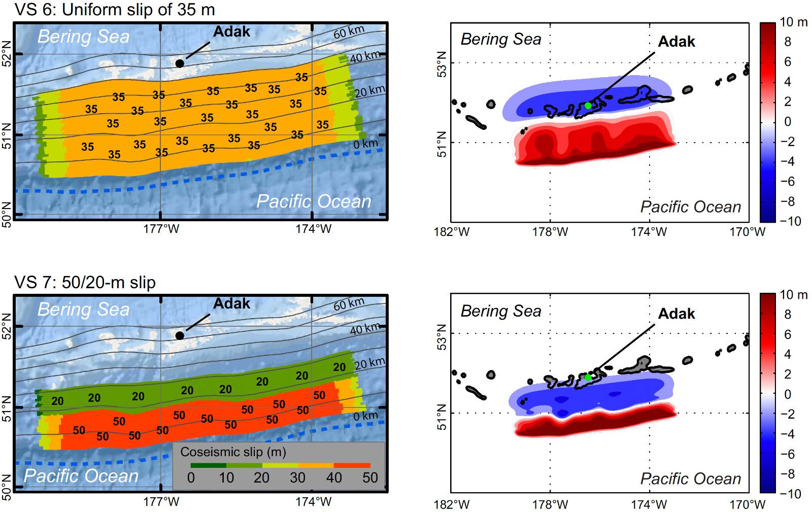
Tsunami Hazard Assessment
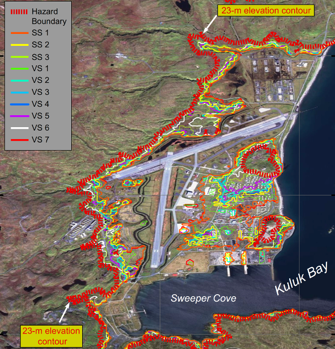
The Alaska-Aleutian subduction zone has the greatest earthquake potential in the Pacific Ocean and produced several major tsunamis in the 20th century. For example, the historic 1946 and 1957 Aleutian, and 1964 Alaska tsunamis resulted in damage and loss of life not only in Alaska, but also in numerous locations around the Pacific Basin. To mitigate tsunami hazard along the Alaska coast and around the Aleutian islands, the Alaska Tsunami Inundation Mapping project aims to develop tsunami inundation maps, estimate tsunami currents, and assess time needed for people to reach safe ground.
Contact: Dmitry Nicolsky
Seismology & Geodesy Group