The Denali Fault
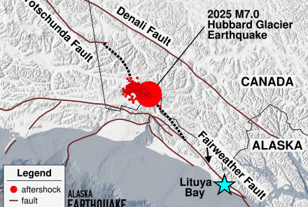
One of the ties between Canada and Alaska is the great Denali fault system that cuts across the whole of southern Alaska, extends on eastward into Canada and then dips back into Alaska near Haines. Its path through Canada and on into Haines is pretty much followed by the Alaska Highway from Koidern, Y.T. (just south of Boundary) to Haines Junction and then by the road on into Haines.
Not obvious to the casual observer, the trench of the Denali fault through the heart of the Alaska Range is easily picked out on topographic maps and is more than obvious in photographs taken from high-altitude aircraft or satellites.
It is now known that there has been major westward displacement of the land on the south side of the fault relative to that on the north. The highest estimates of the displacement give a figure of 400 km (250 miles) during the past 60 million years. Over this time span, this averages out to a motion of about 2 feet a century or six-tenths of a centimeter per year. Thus, instead of being where it is now, Mt McKinley--if it existed about 60 million years ago--would have been in eastern Alaska, not far from Tok, since Mt. McKinley sits just on the south side of the Denali fault.
One place to see the Denali fault is where the Richardson Highway crosses it near the terminus of the Cantwell glacier, the glacier itself lies in the rift trench, as does the upper stretch of Black Rapids glacier, off the west out of sight from this location.
Another spot is on the Parks Highway a few miles north of Cantwell. The bridge across the Nenana River at Windy lies in the fault trench.


