The Hawaiian-Siberian Express
On Christmas Eve, I was working outside my Fairbanks home in above-freezing temperatures. The following day, football fans nationwide watched the Sun Bowl game in El Paso played in a snow storm. This reversal of expected temperatures has been rather common in the last eleven years, and occurred at times (the 1962-63 winter, for instance) in earlier years. The culprit (or benefactor, from the Alaskan point of view) is something called the Pacific-North American circulation, or PNA for short.
The sun in fall and winter heats the Northern Hemisphere very unevenly. While the equator is still being warmed, air in the Arctic cools steadily, at a rate of around a degree or two a day. The rotation of the earth prevents this cooling air from mixing with the warmer air farther south, so a great dome of cold air builds up over the Arctic, bounded at its southern edge by a zone of rapid temperature change called the Arctic Front and by the great river of westerly winds aloft called the jet stream. Half of the snow in the Interior of Alaska comes from the minor shifts in position of this Arctic Front.
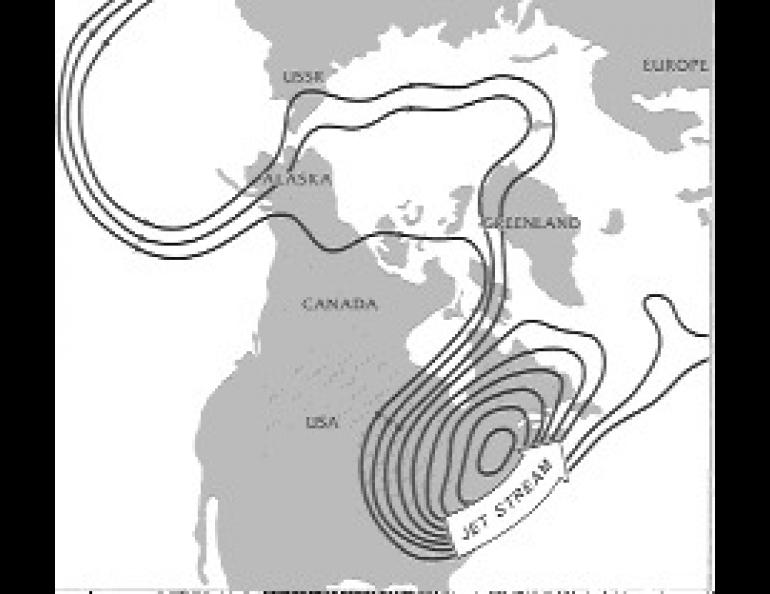
Minor shifts, however, are not enough to keep the cooling arctic air and the warm air of the tropics in balance. By December, the situation has become unstable. The jet stream begins to form large loops and meanders, bringing great blobs of Arctic air southward at some longitudes, while it carries warmer tropical air poleward in other places.
The global distribution of cold land and warm water , together with the positions of the world's great mountain ranges, makes the arctic air more likely to move southward in some places than others. The flow of warm air northward into the Arctic (which must happen at the same time, to keep the total amount of air in the Arctic constant) has to occur at some other place -- usually around a sixth of the earth's circumference, or four time zones, farther west.
The region east of the Rockies is a favored path for arctic air to move southward, and Alaska is just far enough west of that region to benefit from the compensating northward flow of warm Pacific air. This PNA pattern has often been dubbed the "Siberian Express" by people in the path of the arctic air, but here in Alaska it might just as well be called the "Hawaiian Express." In an extreme case, the jet stream may blow from just north of Hawaii to the Mackenzie delta area and even continue on around the North Pole, from which it can plunge straight for the Mexican border before swinging northward again off the east coast.
Once the PNA pattern is well established, it may last with minor fluctuations for a month or more, sending blob after blob of frigid arctic air into the eastern, central, and sometimes even southwestern United States while Alaskan temperatures may exceed those in New York or, rarely, the southeast or southwest.
The El Paso snowstorm was a result of one such arctic outbreak. A far more tragic result of an exported blob of arctic air was the Challenger explosion of two years ago. Less serious but still making headlines was the first-ever indoor Presidential Inauguration in 1984.
Many scientists think that the PNA pattern is most common in El Nino years, when a buildup of warm water off the west coast of South America disrupts atmospheric circulation worldwide. It also seems to have become more common since 1976, and may be partly responsible for the warming we've seen in Alaska. Whatever its origin, it points up the importance of the Arctic to global -- and particularly to North American -- weather.


