
A Little River makes a Big Impression
Visitors to the Valley of 10,000 Smokes in Katmai National Monument are confronted with the startling sensation of emerging from a verdant forest into a stark moonscape. From Overlook, which is the furthest point that the ranger bus takes visitors, all that lies behind is green; all ahead is bleak and barren.
The Katmai eruption of 1912 was one of the most violent in recorded history. The resulting ashfall nearly buried Kodiak and other villages on the southeast side of the Aleutian Range, but it was not until 1916 that R.F. Griggs led a National Geographic party over the pass and discovered the Valley of 10,000 Smokes.
Literature and brochures on the Valley abound, but I would like to focus here on only one small aspect that is frequently neglected--the Lethe River (in Greek mythology, the Lethe was the river of forgetfulness in the underground).
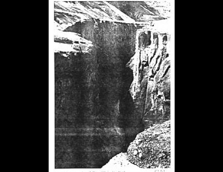
The Lethe is a marvel of erosion. At Overlook, near its lower end, the river is fairly wide and shallow, but if one were to hike ten miles or so to the the upper stretches, things get, as Alice would say, "curiouser and curiouser." At about mid-point, the Lethe is a turbulent rapids tumbling along in a narrow chasm cut into the tuff with vertical sidewalls 100 feet high. So sheer are the walls and so vicious the current, that it is a virtual certainty there could be no escape for anyone trapped at the bottom.
This is impressive enough in its own right, but the real shocker comes in the upper reaches, and for a totally unexpected reason. Whereas the enormous power of the current in the canyon demonstrates that a considerable amount of water is being transported, in some of the upper parts the river is transformed into what at first appears to be a placid stream flowing almost exactly at ground level--and it's only five feet wide! One would almost be tempted to try to wade across it, but this would be a disastrous mistake, because probing with a 30-foot pole would not find the bottom, and only a short distance downstream, the river changes abruptly into the canyon rapids. It gives a positively eerie feeling to be standing there looking at this rippling little creek and knowing that the bottom is, to all practical purposes, "out of sight." It has eroded straight downward, with essentially no sideways migration whatever.
Another facet of the Lethe that intrigues geologists is that, under normal circumstances when dealing with typical valley fill material, it would take at least centuries to create a canyon like that of the middle Lethe. Even more surprising, the records left by Griggs and his party show that the configuration in 1916 was essentially the same as it is today. In other words, in four short years, the river worked its way down over 100 feet below the surface of the ash flow to its present stabilized base level. Even in such soft material as tuff, this defies the imagination.
To underscore a point made earlier, the easiest way to cross the Lethe on foot is to jump across at its narrowest point. It looks so deceptively easy that it's dangerous. In 1953 a geologist named Werner Juhle was participating in a geological survey sponsored by the National Park Service. Juhle left camp one morning and never returned. A search for him revealed his footprints leading up the narrow part of the river and his knapsack on the other side but no footprints. A peak in Katmai National Monument has been named for him.


