Migrating Earthquakes
When the earth's crust is stressed until failure occurs, the ensuing seismic activity often exhibits a tendency to spread out from the initial point of rupture into surrounding areas. Sometimes the activity progresses along a fault, as is common on certain segments of the San Andreas fault in California. Where a well-developed fault system is not present, earthquake activity may spread out radially, while the area undergoes what is known as "relaxation." In still other areas, activity may hop haphazardly from one point to another, filling in "gaps" in the overall pattern of seismic energy release.
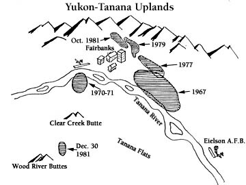
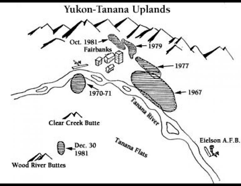
Interior Alaska, particularly in the Fairbanks area, exhibits characteristics of the latter kind of seismicity. Continuing earthquake activity attests that the crust here is in a highly stressed state, but it is difficult to speculate, much less predict, where the next large earthquake might occur. On December 30, 1981 there occurred the largest earthquake near Fairbanks since a series of magnitude 5 to 6 earthquakes southeast of the city in June 1967. The magnitude 5.2 earthquake of December 30 and its accompanying earthquake swarm of about 80 events lay 20 miles south of Fairbanks and almost 30 miles from the 1967 epicenters.
This is not the first time since 1967 that sporadic bursts of seismic activity have occurred in closely-confined and clearly separable areas surrounding Fairbanks. In fact, there have been at least four other notable sequences, each comprising from about 50 to several hundred unfelt earthquakes, with an occasional window-rattler. The first of these was in late 1970 and early 1971 when a very compact focal zone developed about five miles southwest of Fairbanks near the Tanana River.
The second was in February 1977 when an elongate grouping appeared east of the city. The epicentral area of that swarm has since been extended about 15 miles to the northwest by successive swarms in February 1979 and October 1981. Taken as a whole, the latter three groupings along with the 1967 earthquake zone, which has remained active to the present, strongly suggest that a NW-SE trending fault passes east of Fairbanks. Even if that is so, it is unclear what role the latest earthquakes and the 1970-71 swarm southwest of the city play in the overall pattern of tectonic deformation in the area. About the most that can be said is that strain which has accumulated is being released at various points when the strength of the crust at that point is overcome. Studies indicate that the fundamental deforming mechanism is the northward thrusting of the crust underlying the Tanana Flats into the mountainous region of the Yukon-Tanana Uplands north of Fairbanks.
Due to thick flood plain deposits over most of the area, it is unlikely that faults, even if they exist at the bedrock level, will ever be exposed at the surface. A further tantalizing clue that a major unmapped fault may pass near Fairbanks is that a major, magnitude 7.3 earthquake occurred near Salcha, 35 miles to the southeast in 1937. Old timers may reminisce on that one and we'd be particularly grateful to anyone who could supply us with details.