
Welcome to the Geophysical Institute!
The Geophysical Institute is a research facility of various science disciplines where faculty, staff and students work together to turn observations into information, from the center of the Earth to the center of the Sun. GI scientists conduct research in space physics and aeronomy; volcanology; remote sensing; snow, ice and permafrost; tectonics and sedimentation; atmospheric sciences; and seismology and geodesy. The GI also operates research facilities, such as the Alaska Center for Unmanned Aircraft Systems Integration, the Alaska Satellite Facility, Poker Flat Research Range and others.
This self-guided tour highlights some key aspects of work underway at the GI that are represented by objects and information located outside the institute. The tour will give you a glimpse into the work conducted at the Geophysical Institute and illuminate some of its rich history. If you have any questions, email uaf-gi-public-info@alaska.edu or call 907-474-7558.
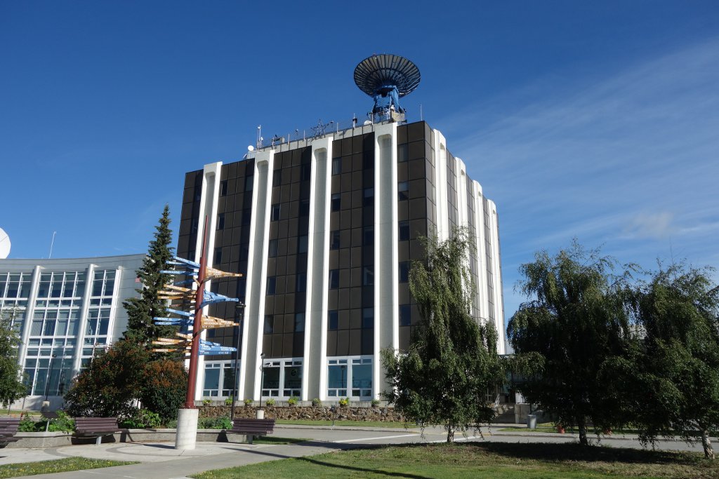
Elvey Building
 64°51'34.13"N 147°50'58.11"W
In 1946, an act of Congress authorized appropriation of funds for hiring staff and construction of an earthquake-proof three-story building for the fledgling Geophysical Institute. The institute eventually outgrew the original building and the seven-story C. T. Elvey Building was completed in 1970.
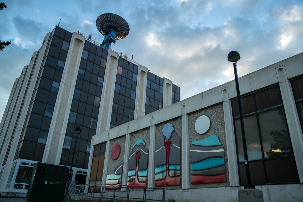
A 29.5 foot diameter blue satellite-tracking antenna on top of the building is operated by the institute’s Alaska Satellite Facility for NASA. A weather and gamma radiation monitor also sits atop Elvey, and another is in the hills nearby. These instruments gather data for UAF, Los Alamos National Laboratory and the Alaska Department of Environmental Conservation.
Christian T. Elvey was managing director of the Geophysical Institute from 1952-1963 and was the university's first vice president for research and advanced study from 1961-1963.
Geo-Odyssey Mural
64°51'33.77"N 147°50'57.04"W
The enameled porcelain steel mural across the front of the Elvey Building is named “Geo-Odyssey.” It was created by Alaska artist Keith Appel in 1993 as an Alaska State Percent for Art commission and installed when the building annex was completed. The red portions of the mural represent volcanic eruption, and the blue pieces symbolize emerging water. The sun and moon represent gravitational forces.
Satellite Antennas
64°51'33.71"N 147°50'59.80"W
The big blue antenna on top of the Elvey Building and the two white antennas in the woods to the west are operated by the GI’s Alaska Satellite Facility. The ASF ground station provides downlink, command and tracking support for satellites in near-earth orbits that are operated by NASA and other space agencies. The near-arctic location of the ASF ground station puts it in an ideal spot for supporting satellites in polar orbits. ASF is also a NASA Distributed Active Archive Center, one of 12 such facilities across the U.S. that archive and distribute earth observation data. ASF currently stores almost 10 petabytes of synthetic aperture radar data that were acquired by a variety of aerial and space-borne sensors starting in 1978. These data are distributed for free to users from all over the globe.

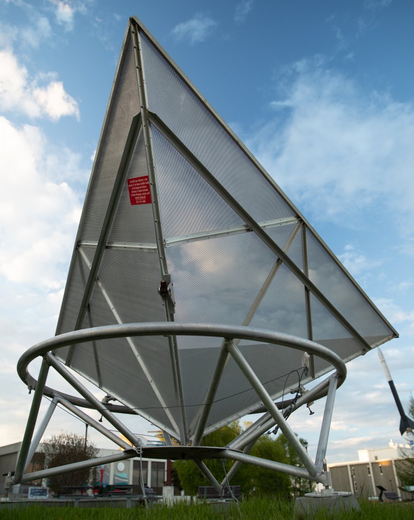
Corner Reflector
64°51'31.90"N 147°50'59.12"W
Directly south of the GI, next to the parking lot, you’ll see what looks like a 15-foot inverted pyramid made of metal. This is a corner reflector used by the Alaska Satellite Facility. Corner reflectors are used to calibrate synthetic aperture radar instruments that are on board satellites in low-earth orbits. The Alaska Satellite Facility maintains an array of these reflectors in precisely-known locations in Fairbanks and Delta Junction, Alaska.
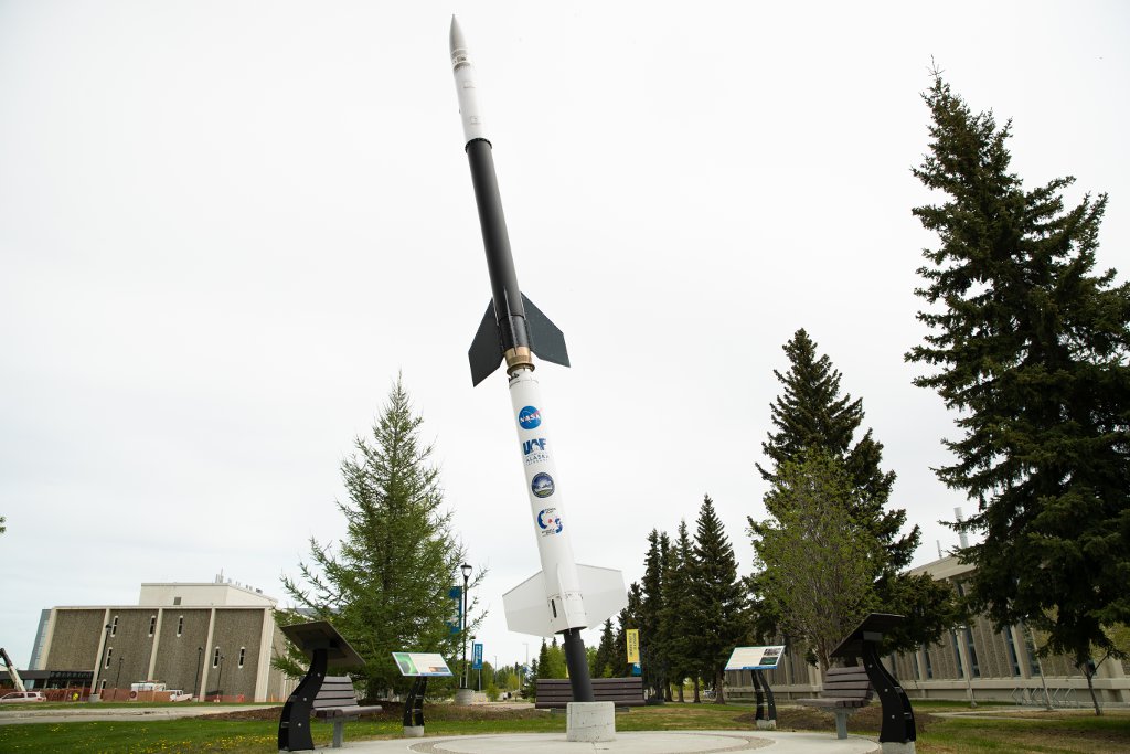
Notice the Rocket?
64°51'32.35"N 147°50'56.38"W
A Black Brant IX sounding rocket stands in the park strip across from the front of the Geophysical Institute. Hundreds of similar rockets have been launched by NASA from the GI’s Poker Flat Research Range—the world’s only university-owned rocket range, about 30 miles north of Fairbanks—to study the aurora and near-Earth space. Interpretive signs at the rocket’s base provide details about the Black Brant as well as information about Poker Flat and the aurora borealis.
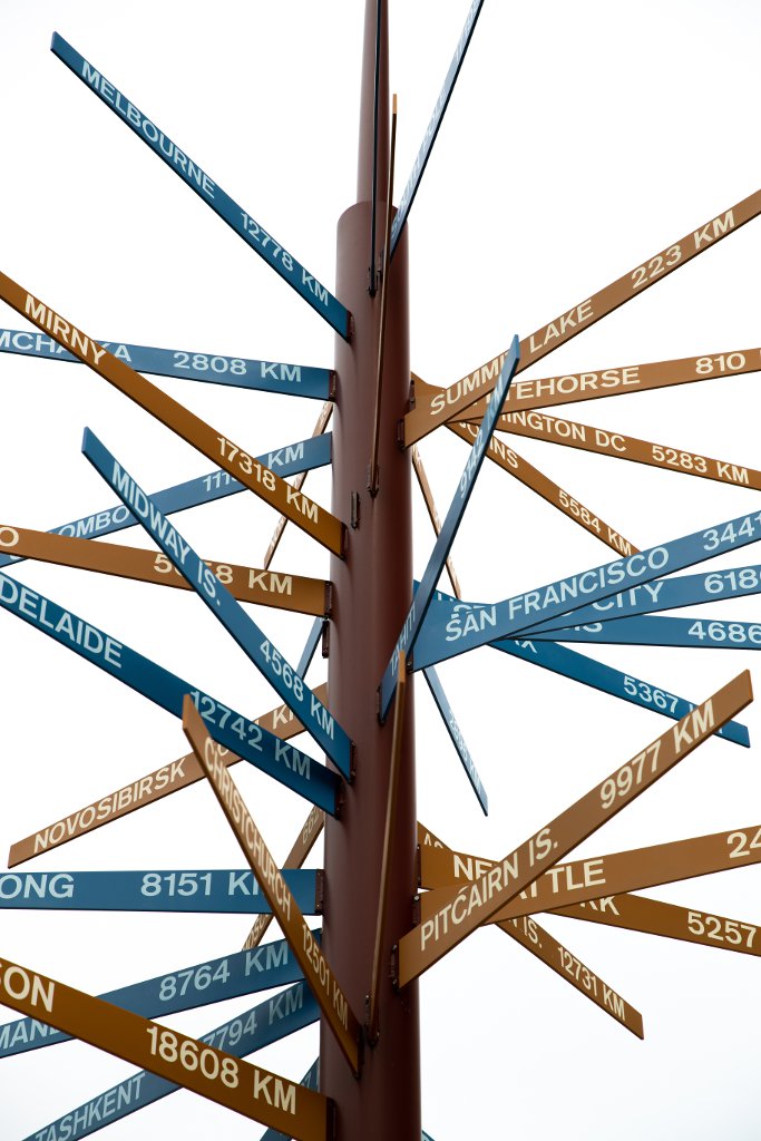
International Signpost
64°51'32.40"N 147°50'58.07"W
In 1973 Keith Mather, an Australian geophysicist and director of the Geophysical Institute, decided it was important to be sure visitors and new graduate students knew just where in the world we were (and still are except for continental drift). He also wanted to highlight the institute’s scientific connections around the world.
Mather and his colleagues decided to install a signpost pointing out different world locations. GI experts carefully calculated the great circle azimuths and distances in kilometers (the units used by scientists around the world) to each of the locations. The GI Machine Shop designed a vertical spiral mounting pattern to allow the signs to be grouped on a post.
GI surveyor Merritt Helfferich provided a known azimuth so the sign could be correctly installed. It would not do at all for someone to set off on a journey to the North Pole, Melbourne, Summit Lake, or Pitcairn Island and be headed in the wrong direction!
The sign was a thing of beauty and quickly became a visitor destination. Unfortunately visitors also found it attractive for climbing. The pressure of a leaning adult or climbing child would break off the 48-inch long signs and the GI Machine Shop was kept busy reconnecting them. In 2008 the taller and more durable replacement you see here was installed. Subsequent revisions and additions have resulted in 39 signs pointing to spots around the planet.
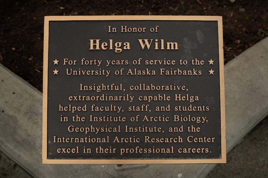
Helga Wilm Dedication
Just to the west of the signpost a plaque next to the garden area commemorates 40 years of service to UAF by Helga Wilm. Helga served as assistant to the director at both the Geophysical Institute and the International Arctic Research Center. She was an astute problem solver, skilled at bringing a big-picture view to the untold challenges that crossed her desk.
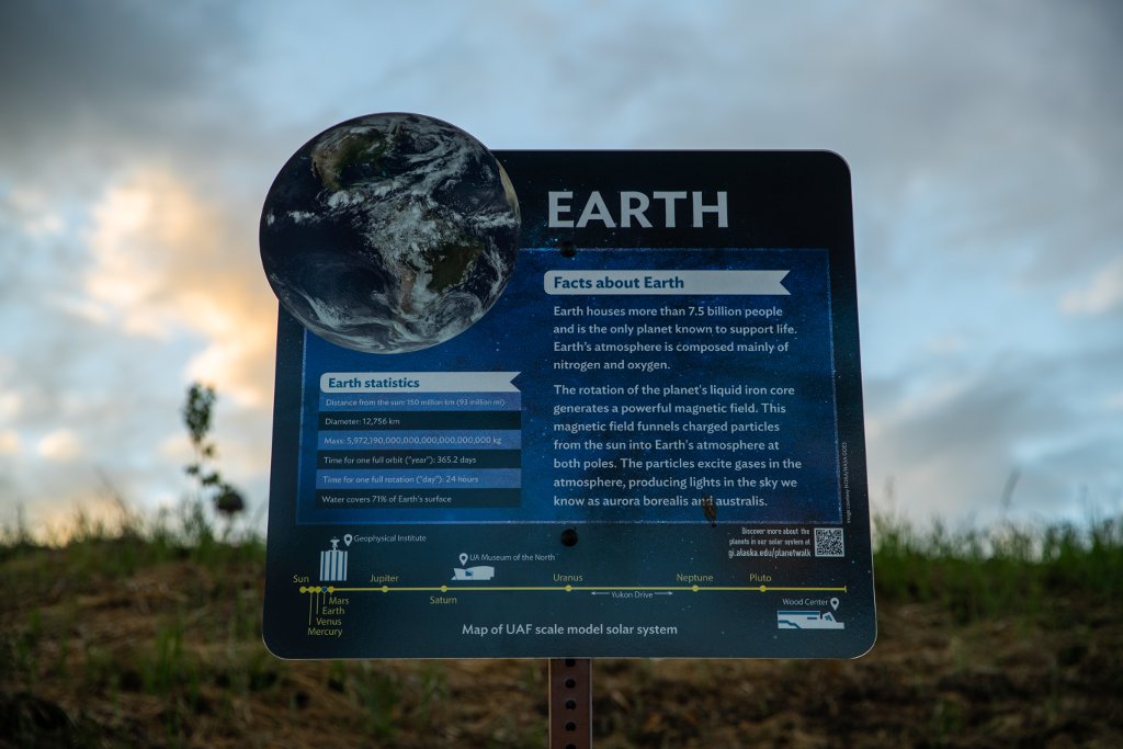
Planet Walk
64°51'29.12"N 147°51'10.91"W
Take an out-of-this-world stroll along the UAF Planet Walk! In a little less than one-mile walk you can follow a scale model of the solar system beginning at the west end of Yukon Drive, near the intersection with Koyukuk Drive. As you move east along Yukon Drive, nine signs represent the sun, Mercury, Venus, Earth, Mars, Jupiter, Saturn, Uranus and Neptune. A 10th sign highlights Pluto, which was reclassified as a dwarf planet in 2006. Each station presents an image and information about the planet. The start and end of the Planet Walk is marked in Google Maps.
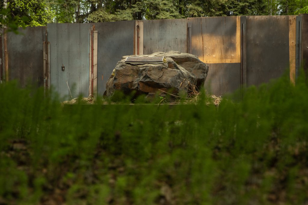
Townsend Point
64°51'37.38"N 147°50'20.96"W
A marker mounted on a boulder behind the UA Museum of the North commemorates the service of Jack Townsend, a USGS employee who helped Geophysical Institute scientists establish and maintain geophysical observatories on the UAF campus.
Thank you for stopping by!
Please visit the Geophysical Institute web pages at www.gi.alaska.edu for more information about research at the GI.