
Information from space, via Alaska, for 20 years
As late August brings night back to the far north, our old friend darkness is restoring our view of the aurora, stars and satellites, seen as pinpoints of light streaking through the heavens. In the last 50 years, researchers have blasted thousands of these devices into Earth’s orbit.
In 20 years of existence, the Alaska Satellite Facility at the University of Alaska Fairbanks has gathered millions of data bits from satellites through its giant antennas. Scientists have used the view from space to study things that are hard to see any other way, including the amount of northern sea ice that forms (or fails to form), or the slight inflation of an Aleutian volcano that may hint of an eruption.
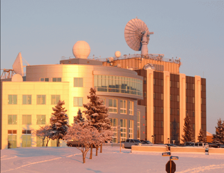
All of this action takes place through one of the most noticeable features of the Fairbanks landscape: a 10-meter dish sitting on top of the Elvey Building on the UAF campus, as well as a similar antenna in the woods a bit west of the Elvey Building. The Alaska Satellite Facility has received data from eight NASA satellites, two satellites owned by Canada, a satellite owned by 13 European countries, and a satellite owned by Japan.
When it all began, in August 1991, technicians at the fledgling facility crowded around a computer in Fairbanks and saw islands and giant rafts of ice north of Hudson Bay, Canada, transmitted to them from a satellite 500 miles overhead. They compared the snapshot from above to maps of northern Canada and marveled at the view Alaska’s newest scientific tool provided them. Since then, they’ve offered space-gathered data to scientists all over the world. Just as important, they often convert all those zeroes and ones into products scientists can use. In a recent example, the university’s Franz Meyer crunched numbers into a program that allows scientists to detect inches of movement on the northern sea ice platforms from which people hunt whales and seals.
“This is a major advance and may change how we look at ice stability,” said Hajo Eicken, an ice expert at the Geophysical Institute.
At the time of ASF’s birth, officials at NASA were contemplating sending a new satellite into orbit, but decided a station that could retrieve data from Earth-observing satellites was a better use of their money. They installed the antenna on the top of the eight-story Elvey Building on West Ridge.
Radar sensors on orbiting satellites retrieve images of Earth even through cloud cover or darkness. Riding aboard the Canadian satellite known as RADARSAT-1 is a synthetic aperture radar instrument that sends down microwave pulses that hit glacier, sidewalk, ocean, and other surface features. Those features can either scatter microwave signals or reflect the signals in varying degrees back to the satellites. Calm lakes, for example, tend to bounce the microwaves away. Trees and buildings reflect more of the microwave signal back to the satellite and show up on images as a lighter color than the pure black lakes.
Scientists use ASF data to solve dozens of problems that are hard to tackle from the ground. Researchers with the Alaska-Pacific River Forecast Center in Anchorage use satellite images to monitor ice sheets on the Yukon River; scientists at NASA’s Jet Propulsion Laboratory used images to check out urban stormwater runoff from Los Angeles into Santa Monica Bay; UAF researchers have used the data to monitor ice “break-offs” that could strand Native hunters off Alaska’s northern coast, and NASA researchers used synthetic aperture radar’s ability to see through clouds to make a map of Antarctica.
For those in the Fairbanks area who want to learn more about the Alaska Satellite Facility and help celebrate the 20th anniversary of those first images from north of Hudson Bay, come to the open house on Saturday, August 20, from 10 a.m. to 3 p.m. at the Elvey Building. The celebration will be easy to find; look for the building with the giant bird dish on top.


