A New Idea About Orderly Arctic Lakes
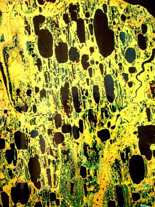
For more than 50 years, scientists have wondered why the lakes of arctic Alaska are so similar to one another. The lakes are long, thin, and point in the same direction, like salmon swimming upstream.
A scientist from Tucson has a new theory about this order among disorder on Alaska’s North Slope. Jon Pelletier studies geomorphology—the study of how landforms come to be—at the University of Arizona. He wrote a paper about the oriented arctic lakes that appeared in the June 30, 2005 issue of the Journal of Geophysical Research.
Less than 10-feet deep and ranging from puddle-size to more than 15 miles long, the parallel lakes on the North Slope cover an area about twice as large as Massachusetts. Similar lakes exist in other northern places, like northern Canada and northern Russia.
Ever since scientists first identified the quirky Alaska lakes in 1949, they have had theories as to what shaped them. Because the lakes point northwest, some thought the sun might be warming the south-facing slopes of the lake, melting the permafrost beneath the surface, and expanding the lakes northward as thawed soil collapsed into them.
A graduate student named Charles Carson traveled to Barrow in the 1950s to study the lakes. It was so foggy during July and August he thought the sun didn’t have much effect on exposed slopes. Constant winds that rattled his tent made him think they might have something to do with the lake formation. He found the winds blew mostly perpendicular to the lakes, causing eddies in the shallow lake water. He concluded that the wind-caused eddies might be eating soil from both ends of the lakes and expanding them north and south.
Carlson’s idea prevailed for many years, but Pelletier, the landform scientist from Tucson, didn’t buy it.
“The way that a landscape evolves is super complex,” he said. “The old explanation had never really done it for me.”
One might ask why a scientist in the southwestern desert is interested in lakes a few thousand miles away. Pelletier answered with enthusiasm.
“Northern Alaska is one of those classic places that get all sorts of strange landforms—ice-wedge polygons, oriented lakes, lines of stones (from repeated freezing and thawing of the ground),” he said.
Pelletier traveled to Barrow in 2004 to check out the oriented lakes. He combined his first-hand view with 1,400 images of the lakes from synthetic-aperture radar images (received through the big antenna dish at the Geophysical Institute in Fairbanks) and added a computer model to help him come up with a new theory.
The lakes form on sloping terrain, with northern ends of the lakes lower than the southern ends, Pelletier said. Warm summer temperatures penetrate more completely into the lower northern ends of the lakes, thawing the permafrost and causing tundra to slump into the lakes, Pelletier said. The lakes thaw more in the downhill direction than the uphill direction, and the lakes grow in a northerly direction year after year.
Pelletier will visit Alaska again in summer 2006 to check his theory, and he’ll also compare images of the lakes today to those taken by the military decades ago to see if they’re expanding northward. He’ll also see if he can relate lake growth to warmer air temperatures recorded in Alaska during the same time frame. No matter what he finds, he’ll remain fascinated with the shallow, orderly lakes of northern Alaska.
“Some of these lakes are expanding five meters (about 15 feet) per year, year-in and year-out for thousands of years,” he said. “They are the fastest growing lakes in the world, and maybe even the fastest geomorphologic process on Earth."