New Wave of seismic modeling: using supercomputers to study earthquakes
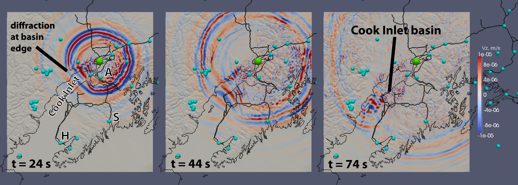
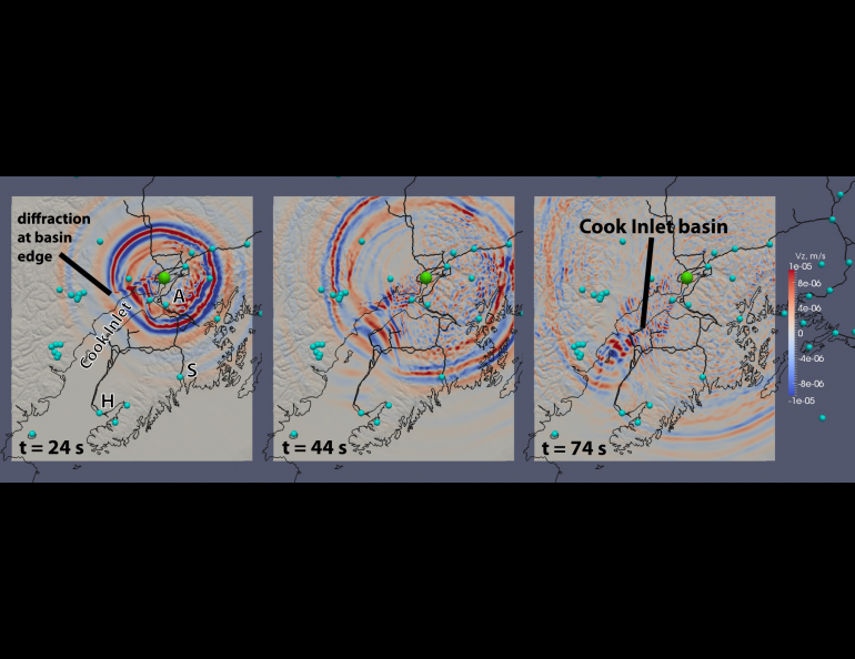
Red and blue waves triggered by a magnitude 4.6 earthquake rippled outward from the Anchorage area and fizzled out after 45 seconds. Except in Cook Inlet basin, where the waves were trapped for another half-minute, bouncing back and forth, up and down, within the 7.5-kilometer-thick sedimentary basin.
“It’s like throwing a rock in the pond. Except water is a homogeneous material. In the solid earth you have basins and mountains and other variations,” said Carl Tape, a seismologist and assistant professor at the University of Alaska Fairbanks.
The actual Cook Inlet earthquake occurred in 2009. Tape is using supercomputers to do the first detailed three-dimensional simulations of earthquakes in Alaska with computational models that he has played a major role in developing over the past 10 years. The models are too complex for regular computers, using codes that track the seismic waves at millions of grid points at each time step. They are also far more accurate than traditional seismic models, factoring in the physics of three-dimensional wave propagation, the topography of the earth, and tons of geological data.
Tape has two main research goals: to model the ground motion caused by earthquakes and to build a high-resolution picture of Alaska’s crust and underlying mantle. This will help seismologists predict the shaking intensity of earthquakes with a whole new level of accuracy, which could help responders better prepare for big earthquakes.
Alaska gets 35,000 earthquakes every year, far more than anywhere in North America.
“The whole state is constantly deforming,” Tape said.
The earth’s plates are always stirring beneath us. As the Pacific plate south of Alaska slides northwest, it dives beneath the North American plate, setting off frequent earthquakes in southern Alaska, the Alaska Peninsula and the Aleutians. Interior Alaska’s earthquakes rupture on faults created by these plates colliding.
“They’re stuck. They keep driving together and every 100 years or so you will have a big earthquake and release all that accumulated strain. And then they’re stuck again,” Tape explained.
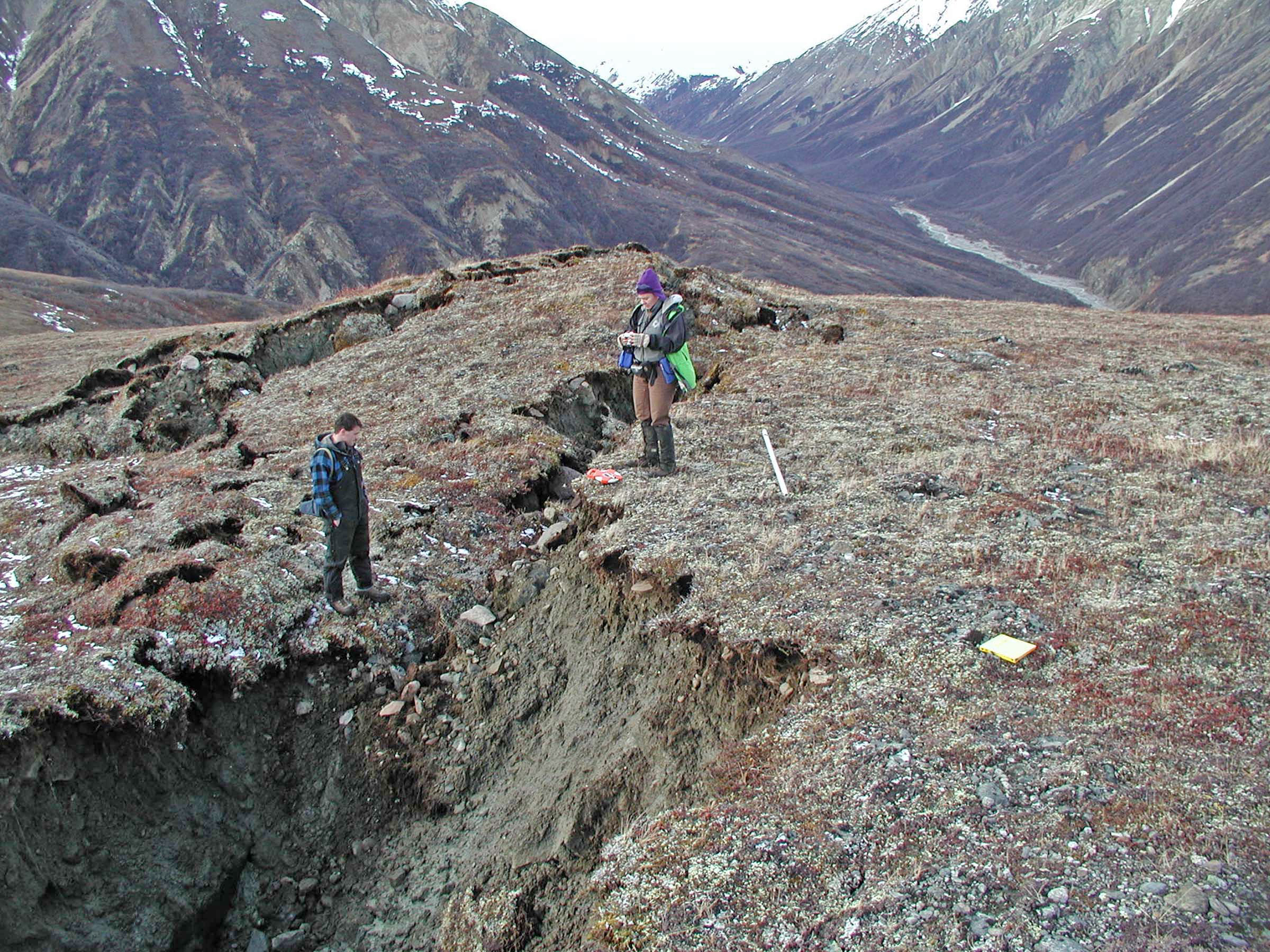
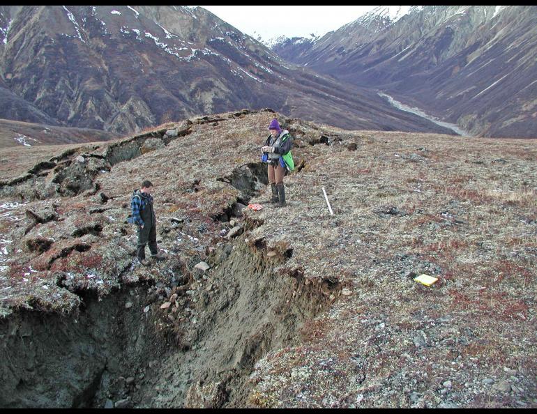
During earthquakes, shaking is intensified in basins, “bowls” of sediment (or super-compacted sand or dirt) that hasn’t yet turned to rock. “It excites the basin and you get stronger shaking for longer,” Tape said. Alaska is full of these basins—Cook Inlet basin, Nenana basin (Minto Flats), and on the North Slope—which often contain the most coal, oil and gas potential.
Most of what we know about earthquakes comes from about 150 seismometers across the state. These stations, maintained by the Alaska Earthquake Information Center, are constantly listening for earthquakes and provide critical—yet limited—data for seismologists.
“All we have are little wiggles at recorded points,” he said.
The simulations provide a more holistic picture of an earthquake, showing the range of ground motion, the peak ground velocity (maximum shaking) and predictions for the hardest hit areas, like sedimentary basins. He validates the models by reconstructing earthquakes to see if the predicted shaking matches the actual shaking recorded by seismometers.
“We’re trying to fit the true wiggle-for-wiggle ground motion.”
Tape produced a set of seismograms for a recent earthquake near Mount McKinley with red lines of modeled shaking closely overlapping blue lines of recorded shaking. With this kind of accuracy, you can more confidently predict ground motion from earthquakes that haven’t happened yet.
The models are constantly being improved with new data on the earth’s crust, which comes from various imaging techniques used in seismic surveys, oil exploration and other sources. Each simulation helps paint a sharper picture of the crustal landscape and how waves travel through it. Ultimately Tape plans to use the simulations to improve the models of Alaska’s crust by using a procedure similar to medical imaging.
This summer UAF will host the largest seismology conference ever held in Fairbanks to discuss the computational modeling of seismic waves with some of the world’s leading seismologists.
“It’s an ideal venue because we monitor thousands of Alaska earthquakes a year, and we have world-class academic supercomputing resources.”
Watch the simulation of the earthquake near Cook Inlet in Southern Alaska here.
The Alaska Science Forum has been provided as a public service by the Geophysical Institute, University of Alaska Fairbanks, in cooperation with the UAF research community since the late 1970s. Molly Rettig is a science writer who currently works in communications at the Cold Climate Housing Research Center in Fairbanks.