When volcanoes awaken
“This morning the seismic tremor was down just a little bit from yesterday. We’re hoping it calms down before too long, but it might last for awhile.”
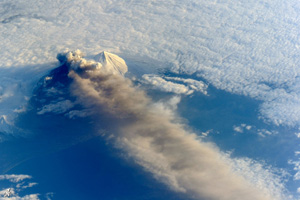
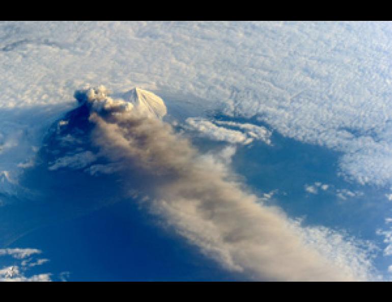
Jeffrey Freymueller was on the phone last week with the electric utility in Cold Bay, a community about 40 miles from the Pavlof Volcano, which had been erupting for more than a week. The utility was wondering how much ash fall to expect and whether it would need to shut down its diesel generators. The ash had exceeded 20,000 feet, grounding several regional flights.
The alert level was downgraded on Tuesday as the tremors and explosions tapered off. Yet Pavlof tends to fluctuate and could always flare up again.
Freymueller is a geophysics professor at the University of Alaska Fairbanks Geophysical Institute and the GI’s coordinating scientist for the Alaska Volcano Observatory, which monitors more than 20 active volcanoes in Alaska and provides information and warning to the public, governments, the Federal Aviation Administration and others.
At 8,262 feet, Pavlof squats near the tail end of the Alaska Peninsula and is among the most active volcanoes there, with nearly 40 known eruptions in the past couple centuries.
While it erupts frequently, it’s a fairly low-energy volcano by Alaska’s standards. Explosivity depends on the chemistry of the volcano.
Magma, or molten rock, contains water and gases (like carbon dioxide and sulfur dioxide). If the magma is sticky and rich in gas, the gas bubbles have a hard time moving out of the fluid and become trapped inside. When magma is released from the earth, the gas rapidly expands and blows the lava into small sand-like pieces (volcanic ash).
“You violently depressurize these bubbles, and that’s the fuel for the explosion,” Freymueller said.
But Pavlof has fairly fluid magma. It doesn’t contain as much gas, and bubbles can mostly dissolve before the explosion.
“You open a soda can. Before you open the can, the gas is all dissolved inside the fluid, and when you depressurize it the gas comes out. The same kind of things happens with molten rock.”
Volcanoes announce themselves in different ways.
Pavlof typically doesn’t give much warning before eruption—with a spate of earthquakes or tremors, for example. So how do scientists know one is happening?
With Pavlof, remote sensing tipped them off first. A satellite weather station showed temperatures of 60 degrees Celsius (140 degrees Fahrenheit) near the summit.
“With that sort of temperature it had to be molten rock at the surface.”
It took a little longer for the ground to start shaking.
“That initial burp didn’t actually produce that much seismic signal,” Freymueller said.
Within a couple days, seismometers about six miles from the volcano caught on to the motion.
Around the same time, infrasound stations hundreds of kilometers away were picking up the sound of lava fountaining. Infrasound is a low-frequency noise produced by volcanoes that’s too soft for the human ear but can be heard by sensitive microphones.
Then pictures of gas, steam and lava started flowing in from pilots, passengers, nearby communities and even an FAA webcam at Cold Bay.
Sometimes GPS, which measures ground deformation, is the most telling.
Before Augustine erupted in 2006, a series of microearthquakes (up to 15 per day) rumbled under the Cook Inlet volcano. It would swell up, explode, go quiet for a couple days and then repeat the cycle. An explosion can often signify the end of the eruption, but GPS showed the ground around Augustine continued to deform.
“Because the volcano was continuing to swell up, despite these explosions, that told us there’s likely more to come,” Freymueller said.
Finally there was a big explosion and the volcano started deflating again.
Scientists get excited about eruptions (the non-harmful ones), as they spew details about the inner workings of volcanoes.
“Huge amounts of information are available when the volcano is active as opposed to when it’s just sitting there.”

