
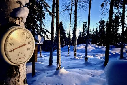


Tsunami awareness a priority nearly 60 years after last major Alaska event
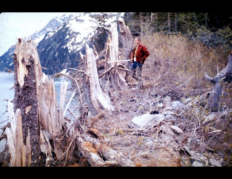
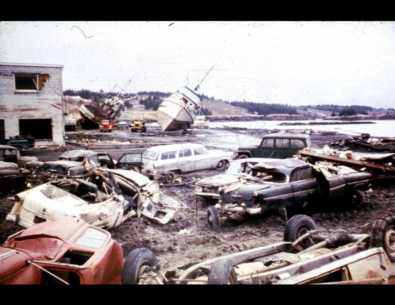
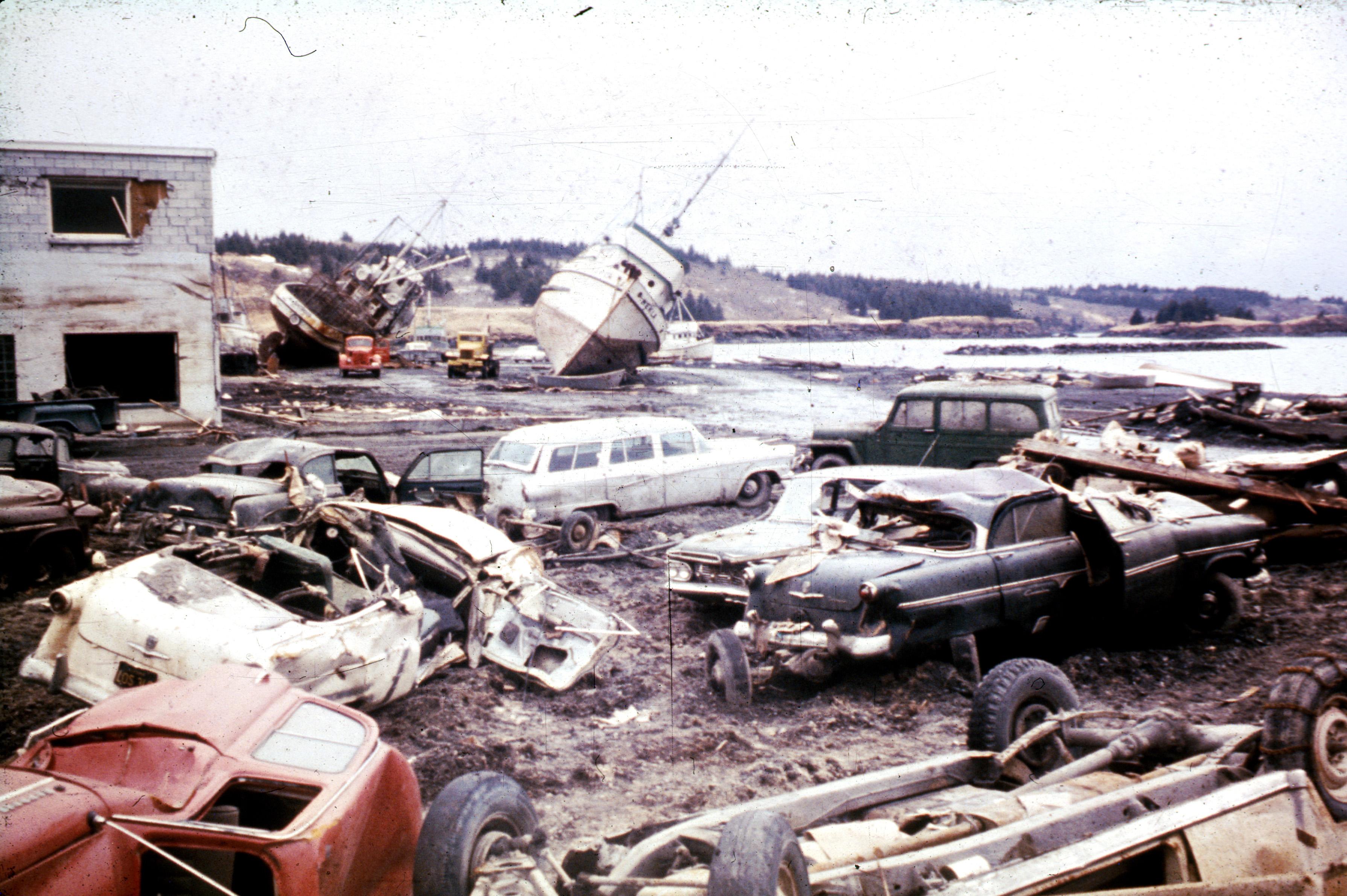
It has been more than half a century since a major tsunami washed itself upon Alaska. The magnitude 9.2 earthquake of March 27, 1964, in Prince William Sound unleashed tsunamis that devastated coastal communities. They wiped out the village of Chenega and wrought damage upon Whittier, Seward, Kodiak and Valdez.
A tsunami that day reached a height of 170 feet near the mouth of Shoup Bay in Port Valdez, 57 years ago this Saturday, March 27, 2021. The tsunamis — the main open-ocean wave caused by the earthquake and local waves caused by underwater landslides in bays — killed 124 people, some even in Oregon and California.
Today, in 2021, nearly 75% of the state’s population was born after the last significant tsunami to strike Alaska, in the Aleutian Islands in 1965. Scientists have expressed concern about complacency.
Raising awareness of such tsunami risk has been a long-running effort of the Alaska Earthquake Center, part of the Geophysical Institute at the University of Alaska Fairbanks. The center also works closely with the Alaska Division of Geological and Geophysical Surveys, the Alaska Division of Homeland Security and Emergency Management and the National Oceanic and Atmospheric Administration.
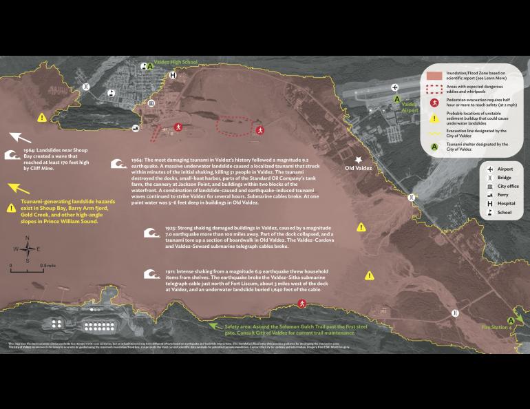
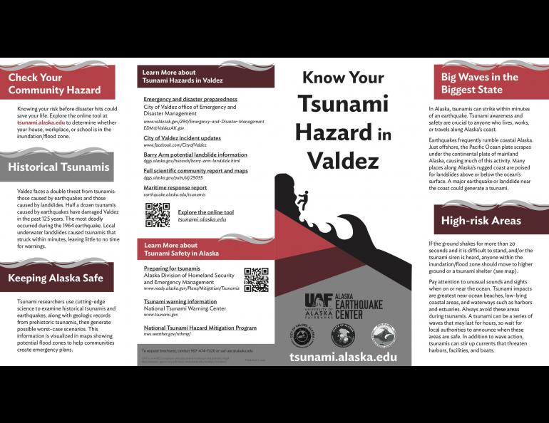
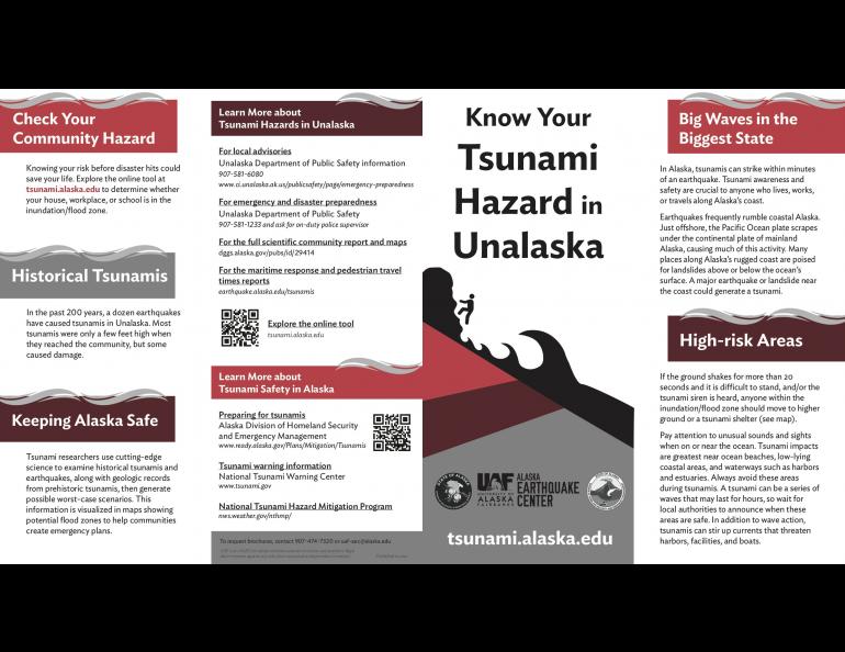
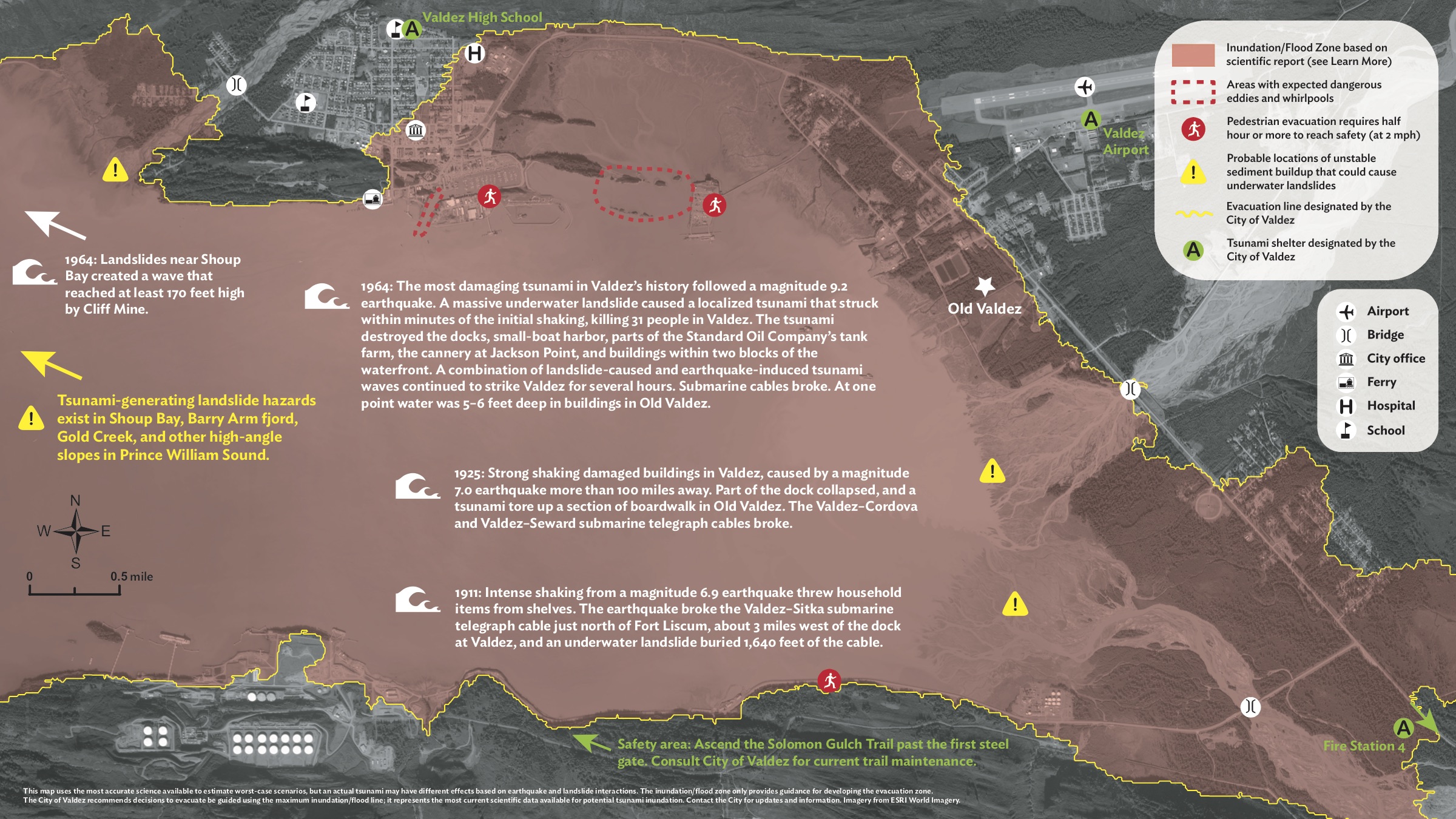
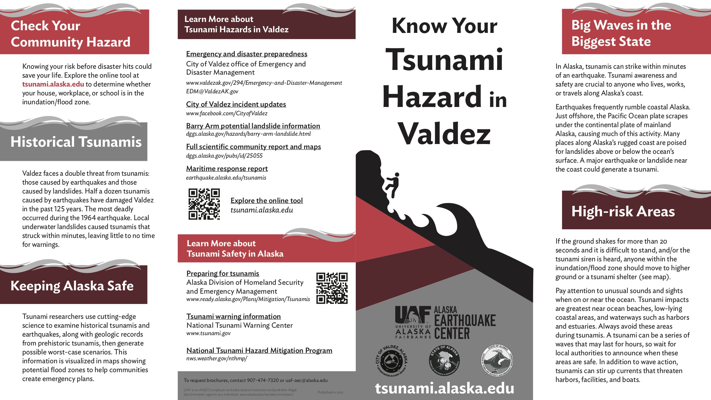
To boost awareness, the Alaska Earthquake Center created two community-specific tsunami awareness brochures that are designed to fit in a pocket or purse and that contain information for coastal residents and visitors in easy-to-understand language. Each brochure also contains a detailed color map showing the inundation zone and safe places.
The Alaska Earthquake Center created one brochure for the Prince William Sound city of Valdez and one for the Aleutian Islands city of Unalaska, each with the strong support and involvement of community officials.
“I hope every household will get one,” said Elena Suleimani, tsunami modeler with the Alaska Earthquake Center. “Then the people will start asking questions about how to evacuate, where, how to get the warning message, etc. The goal is to generate questions and concerns that local authorities will have to address.”
Suleimani is co-author of the Valdez and Unalaska inundation mapping reports and assisted with the brochures’ text and maps. She said the two communities were chosen because of their high tsunami hazard and because they represent different regions of Alaska.
The Alaska Earthquake Center hopes to secure funding to produce the foldout brochures for more coastal sites. Other communities have asked to have tsunami brochures specific to their locations.
Tsunamis remain a significant concern in Alaska because the state has a high number of earthquakes and the longest coastline of any state.
Gov. Mike Dunleavy, in a proclamation declaring this week as the annual Tsunami Preparedness Week, encouraged Alaskans “to be mindful of, and prepared for, a tsunami hazard in their local areas, as we remember how Alaskans and others across the world have been impacted by tsunamis.”
What’s inside?
For the brochures, the Alaska Earthquake Center provided information about tsunami history for each community.
The Valdez brochure notes that the community “faces a double threat from tsunamis: those caused by earthquakes and those caused by landslides. Half a dozen tsunamis caused by earthquakes have damaged Valdez in the past 125 years.”
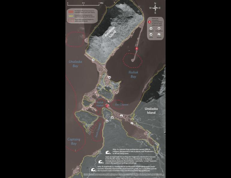
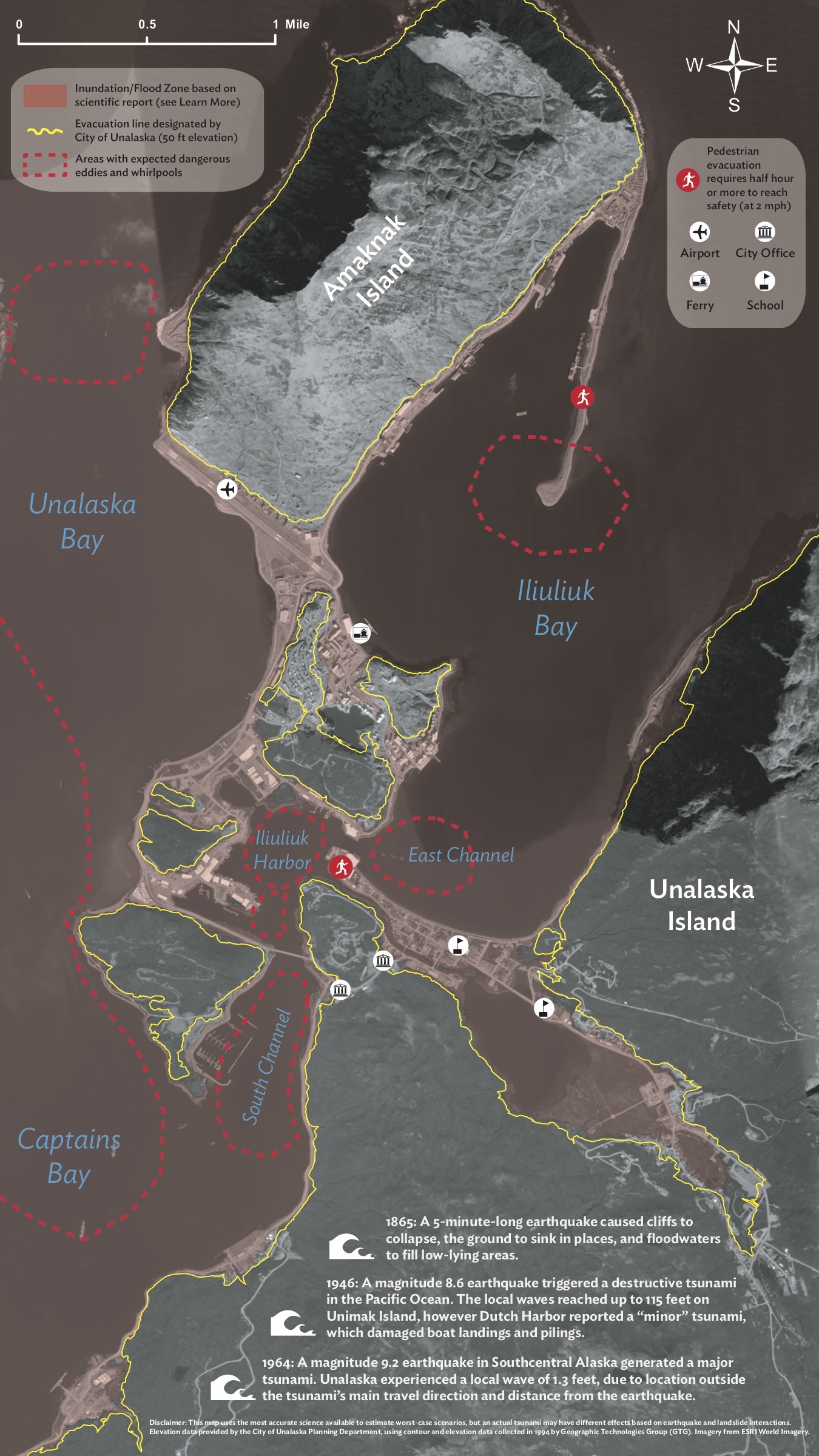
The Unalaska brochure reads, “In the past 200 years, a dozen earthquakes have caused tsunamis in Unalaska. Most tsunamis were only a few feet high when they reached the community, but some caused damage.”
To bring the situation home, each brochure includes a map showing the evacuation zone as determined by each city’s officials. They show locations of shelters and other safe areas and include information on how long it would take a person to reach safety. They also point out locations of possible dangerous eddies and whirlpools.
The Valdez map includes an extra warning about the risk of landslide-generated tsunamis occurring in Shoup Bay, Barry Arm fjord, Gold Creek and other high-angle slopes in Prince William Sound. Scientists have been paying particular attention to the Barry Arm fjord recently due to ground instability.
The brochures include key phone numbers, websites and recommendations for where to learn more about tsunami hazards and safety.
Valdez and Unalaska officials intend to make good use of the brochures. Valdez has 5,200 copiesof them; Unalaska has 1,500.
“The brochure is a key component of education in the city,” Valdez Emergency Manager Aaron Baczuk said. “Much of its content is a direct manifestation of years of dedicated effort within the scientific community in Alaska.”
The city intends to blanket the area with the brochures, sending them to every post office box and putting them at key locations such as City Hall, the harbor, the visitor center and at least 20 businesses.
“The new brochure provides people who live, work and recreate on or near Prince William Sound with a depiction as accurate as possible of the reach and extent of a localized tsunami without them having to be a scientist,” Baczuk said.
Unalaska officials will be spreading the brochures around their city as well, said Bill Simms, deputy chief of police at the Unalaska Department of Public Safety.
“The brochures will serve as a condensed version of our current Tsunami Hazard Map and will be distributed to all public-facing city entities, industry infrastructure and the Unalaska Visitors Bureau,” he said.
The brochures were created with input from Dmitry Nicolsky, the lead scientist for the Alaska Earthquake Center's tsunami program, with development and coordination by communications specialist Beth Grassi and graphic design and maps by seismologist and cartographer Lea Gardine.
“We’re looking for a way to make this possible for all coastal communities in Alaska,” said Michael West, director of the Alaska Earthquake Center.
“We had damaging tsunamis in 1938, 1946, 1964, 1965 and then nothing,” he said. “We have grown complacent, and I don't mean that in a critical sense, but most people living in coastal Alaska today have not actually experienced a tsunami.”
Other Alaska Earthquake Center tsunami resources
The new brochures, and any that will follow for other communities, build on the interactive tsunami inundation map that the Alaska Earthquake Center launched in 2019.
The Tsunami Hazard Map Tool shows a projected maximum tsunami inundation for 55 Alaska communities. The Alaska Earthquake Center staff determined the inundation zone by running multiple scenarios based on earthquakes of different geologically plausible sizes, locations and styles. The zone includes any part of town that is covered by one or more of the scenarios, West said.
Users can zoom in on the highly detailed satellite imagery to zero in on specific buildings to see if they are inside or outside the inundation zone. There’s also a feature that shows the estimated water depth.
The map can be found online at https://earthquake.alaska.edu/sites/all/tsuMap/html/tsunami.html
The Alaska Earthquake Center also has an extensive library of community-specific tsunami inundation reports, which detail a community’s seismic and tsunami history and provide various scenarios. They were produced in partnership with the Alaska Division of Geological and Geophysical Surveys and the Alaska Division of Homeland Security and Emergency Management.
The reports can be found on the tsunami page of the Alaska Earthquake Center’s website: https://earthquake.alaska.edu/tsunamis
Tsunami awareness is a priority for the Alaska Earthquake Center. West and Suleimani both believe Alaskans have become complacent in the more than half a century since the last major tsunami to hit the state.
“This is why our most important job is to keep talking about tsunami hazards, keep reminding people about what Alaskans experienced in 1946 and 1964, and educate them about their options for survival,” Suleimani said.
And it’s not just residents of coastal communities who need to be tsunami-aware.
“People travel to coastal areas all the time, both in the U.S. and internationally. Everyone needs to be aware of the tsunami warning signs,” she said.
Rod Boyce, University of Alaska Fairbanks Geophysical Institute, 907-347-9105, rcboyce@alaska.edu
Lea Gardine, University of Alaska Fairbanks Geophysical Institute, Alaska Earthquake Center, 907-474-7664, lagardine@alaska.edu