No Rest for the Denali Fault
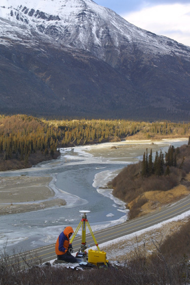
As Lissy Hennig set up a tripod on the flank of Panorama Mountain, I tried to feel the earth move beneath my feet. In the week following the Denali Fault earthquake, the mountain had moved as much as it had in the two years prior, and scientists weren't sure why.
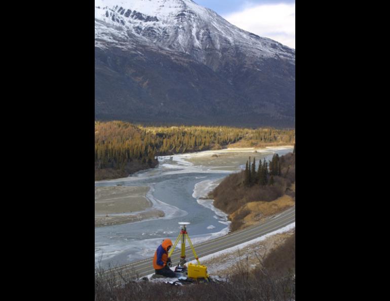
Hennig's boss, Jeff Freymueller of the Geophysical Institute, wanted to find out more about the post-earthquake ground movement along the Denali Fault, so he sent Hennig down the Parks Highway with his tool of choice: global positioning system receivers. The GPS receivers Freymueller uses are sensitive enough to track the movement of Earth's plates, which creep along at the speed fingernails grow. Since the Denali Fault earthquake of Nov. 3, 2002, GPS receivers deployed by Freymueller and others have detected one centimeter of ground movement each day at a site near Donnelly Dome outside Delta. That's about 300 times faster than before the earthquake.
At sites off the Parks Highway that Hennig and I visited, the ground had moved about 2 centimeters during the first week after the earthquake. Before the earthquake, Hilary Fletcher, a post-doctorate researcher at the Geophysical Institute, had measured the ground movement in the area, finding an average of seven millimeters movement each year. Freymueller had installed most of his supply of about 30 high-precision receivers, which he borrowed in haste from colleagues across the country, near where the Denali Fault rupture did the most damage, off the Richardson Highway, Tok Cutoff Road, and Alaska Highway. When he saw the results from a few stations near the Parks Highway, he pieced together a few antennas, receivers, and tripods. He wanted to find out whether a slippage of the Denali Fault west of where it ruptured in the mountains was causing the ground movement, or whether some source deep beneath the surface was to blame.
I traveled down from Fairbanks with Lissy Hennig, a student from Dresden, Germany, who had worked for Freymueller the past few months because she wanted to learn something about using GPS receivers to detect movement in Earth's crust. Hennig's timing was good. Freymueller and other scientists consider the Denali Fault earthquake an event that occurs every 1,000 years or so. Scientists from the University of California at Berkeley and Purdue University traveled north to join Freymueller's group in the response to the earthquake.
The Denali Fault is a weak point in Earth's crust that cuts across Alaska in a trench filled with river valleys and glaciers. The lessons of the Denali Fault earthquake are of particular interest to scientists who study the San Andreas Fault in California. The Denali is similar to the San Andreas in that they are both strike-slip faults; during an earthquake the ground on both sides of the fault line moves horizontally in opposing directions. In between earthquakes, the friction of rock on rock tends to lock strike-slip faults, but researchers can measure subtle movement by setting up GPS receivers on both sides of the fault hundreds of miles away. Though the surface along a fault often doesn't move except during an earthquake, warmer rock about 10 to 15 kilometers beneath the fault continues moving.
The Denali Fault earthquake will give clues to the behavior of underground layers of rock known as the lower crust and mantle. Fletcher hopes to use information being gathered now to find out which part of the Denali Fault moved the most during the earthquake, and to find out more about the structure of Earth's crust and upper mantle along the fault. She, Freymueller, and many other Alaska scientists are keeping an eye on their instruments perched all along the Denali Fault, gathering information that they'll take with them to an international meeting of Earth scientists in San Francisco in December. There, organizers have created a special session on the Denali Fault earthquake at the Moscone Center, which is a short walk from that other famous strike-slip fault.