
Return from the earthquake zone in Haiti
After a few chaotic, free-form weeks in Haiti, an Alaska geologist reported that he and a team of others didn’t find the rips in the ground they were looking for following the early January earthquake near Port-au-Prince.
When Rich Koehler of the Alaska Division of Geological & Geophysical Surveys arrived in Haiti after three days of travel from Alaska, no rooms or rental cars were available. Koehler and his coworkers caught rides to search for the ground features they expected to see and managed to stay with a family in an undamaged home.
“We got really lucky,” Koehler said. “We kind of had to shoot from the hip a little bit, because everything was not functioning.”
While weaving through streets upon which people had set up temporary living spaces, Koehler and others searched in vain for torn ground that showed the expression of the earthquake. Such markers enable geologists to learn quite a bit about the earthquakes that caused them.
“We didn’t find a surface rupture,” Koehler said. “It’s not totally unusual, but the earthquake was so shallow, we thought we’d see it.”
The epicenter of the earthquake was about six miles down.
“Generally with a (magnitude) 7 you’d see a surface rupture,” Koehler said. “But that’s not always the case. This one just didn’t have quite the right punch to do it.”
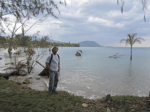
Koehler and his colleagues saw other things in Haiti, like corals lifted high and dry as a shoreline of Hispaniola (the island shared by the Dominican Republic and Haiti) rose about 20 inches due to the earthquake. He also saw trees standing in the ocean a few hundred feet offshore after earthquake-induced landslides.
“And there were rockfalls everywhere,” Koehler said. Some of those avalanches closed roads; Koehler’s colleagues are still getting past those to search for surface ruptures.
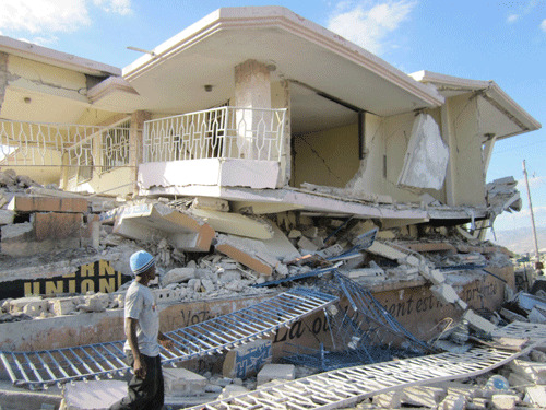
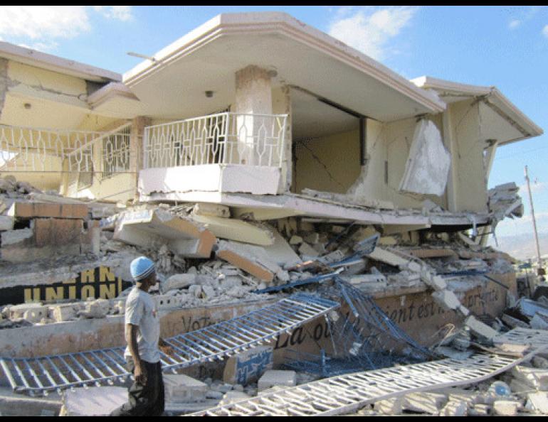
The devastation of Port-au-Prince became most evident to Koehler when he caught a ride in a helicopter above the city. A combination of concrete roofs supported by cinder-block walls made for a disaster.
“Concrete roofs are something of a status symbol because of their hurricane resistance,” Koehler said. “But they proved to be fatal in this earthquake.
“When you fly around with helicopter, it seems like you’re looking down on a lot of basketball courts,” he said.
Those “basketball courts” were concrete roofs that pancaked homes during the earthquake.
“The death toll is more than 200,000 — it’s the deadliest strike-slip earthquake in history,” Koehler said. “It was largely due to bad construction practices.”
Strike-slip earthquakes occur when Earth releases internal stress in a side-to-side motion, which can unzip the ground surface above. The magnitude 7.9 Denali Fault earthquake in 2002 was a strike-slip earthquake; it left a 200-mile scar through tundra and ice in central Alaska.
“If only some earthquakes break the surface, we may not recognize all earthquakes in the (ancient) record,” Koehler said. “We might be underestimating seismic hazards along some faults.”
Though he’s not sure yet, Koehler will probably spend more time in Haiti in the future, as his colleagues are still down there looking for sites that might reveal when giant earthquakes happened in the past. Funding opportunities will probably arise in the wake of the earthquake.
“We’re trying to learn from it, to learn more about seismic hazards in Alaska, too.”
If he returns, Koehler will get to see how a city recovers from such a disaster. He said he already saw more progress than he expected.
“Two weeks after the earthquake people were out recycling materials to build new structures, and street markets were back in action. I was pretty impressed by that. You hear about a place where almost half of the population is killed, you think it’s just done. But people are pretty resilient.”