Where Is The Russian-U.S. Boundary?
Oscar J. Noel of Fairbanks recently brought to my attention a matter about which I am sure few are aware. It involves a border dispute between the U.S. and the U.S.S.R. that has existed ever since the purchase of Alaska.
First, it would be well to define a couple of terms. A "great circle" is the path around a sphere that would be described by the cut of a knife slicing through the center of the sphere. The surface path would be the shortest route to any other point along the cut, but to follow a great circle route at sea, you'd have to change your magnetic heading constantly, unless you were sailing directly toward one of the poles.
The difference, particularly at polar latitudes, is considerable.
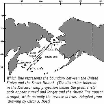
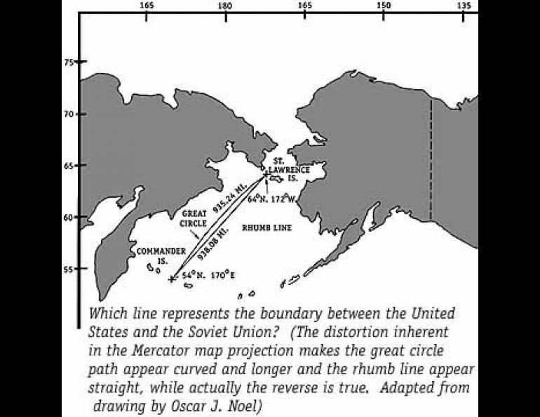
The Russians claim that the northeast-southwest trending boundary between the two countries in the Bering Sea is a rhumb line. The Americans claim it is a great circle. The difference in area involved is over 20,000 square miles. To quote in part from Mr. Noel's letter:
"This dispute has involved the U.S. and the U.S.S.R. in at least two incidents lately. The first is the dispute over sovereignty in the potentially oil-rich Navarin Basin. The second was an incident involving a U.S. crab fisherman in which his boat was chased out of the area, leaving his crab pots. The pots were subsequently recovered with the help of the U.S. Coast Guard.The Treaty of Cession reveals that the most important part of the boundary (as far as the dispute is concerned) runs for almost a thousand miles between two points. The southernmost point lies halfway between Attu Island on the American side and Copper Island of the Commander group on the Russian side. This point would lie near 54 degrees N. latitude and 170 degrees E. longitude.
The northernmost point lies halfway between St. Lawrence Island and Cape Chukotskiy on the Russian mainland, at approximately 64 degrees N. and 172 degrees W. According to the Treaty of Cession, the boundary has to lie between these two points without a break.
I was informed by Mr. Don Lynch at the University of Alaska, Fairbanks, that no original maps made in conjunction with the Treaty of Cession have been found in either Russia or the U.S.
My calculations show a great circle distance between the two points of 935+ statute miles and a rhumb line distance of 938+ statute miles. I am reasonably confident of these figures, but where I run into problems is in determining the (disputed) area bounded by the alternate boundaries.
I will hazard my best "calculated guesstimate" as 1,200 square miles in a section 40 statute miles across at its widest point. If my calculations are reasonably close, it is easy to see why the U.S.S.R. is so protective of such a large area potentially rich in oil, gas and fisheries resources."
I would like to express my appreciation to Mr. Noel for his research and for bringing to our attention this little-known conflict.