
Recent Posts
Alaska climate report: Sea ice growth and other winter transitions
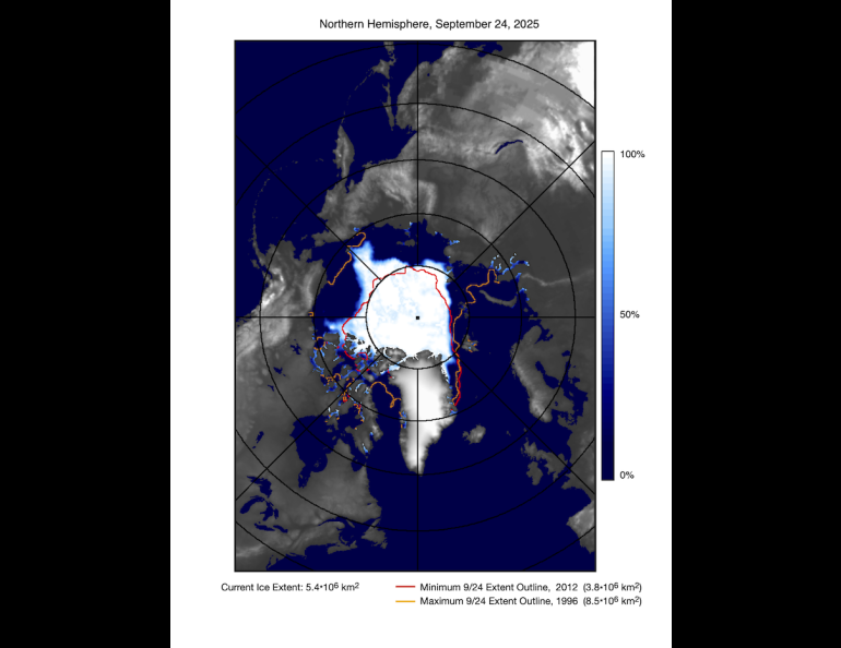
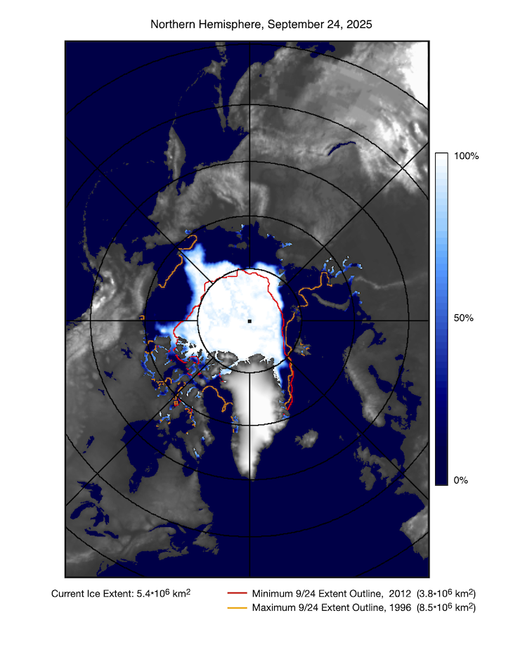
Sea ice has returned to its annual growing season, though it’s a slow turnaround as usual. The Arctic sea ice extent likely reached its 2025 seasonal minimum Sept. 10, at 1.85 million square miles.
That is tied with 2008 and 2010 for the 10th-lowest minimum coverage in the 47-year satellite record, the Alaska Climate Research Center reported in its September monthly summary.
The Alaska Climate Research Center, a part of the University of Alaska Fairbanks Geophysical Institute, released the summary earlier this month.
Weekly increases in Arctic sea ice extent rose to 2% during the second half of the month after hovering at less than 0.5% during the first half.
The ACRC cited data from the National Snow and Ice Data Center.
In Antarctica, winter is turning to summer, beginning the annual sea ice decline. The seasonal maximum extent of sea ice was reached on or about Sept. 17, with 6.88 million square miles of ice.
This year’s maximum extent of Antarctic sea ice is the third-lowest on record after 2023 and 2024.
The transition to winter continued on the Alaska mainland. September demonstrated the state’s vastness and how the transition to winter can vary dramatically by location.
The daily high of 74 degrees in Juneau on Sept. 3 was striking, while just two days later, King Salmon recorded a minimum of 32 degrees.
On Sept. 23, King Salmon experienced a wintry low of 22 degrees. Utqiaġvik reached the same temperature a week later, Sept. 30.
“Few places show the scale of seasonal change like Alaska — where great distances mean autumn can feel like summer in one region and winter in another,” said ACRC Director Martin Stuefer, who is also the Alaska state climatologist.
“September 2025 proved it again,” he said. “While Southeast basked in record warmth, fall storms swept the west, and sea ice tied for its 10th-lowest mark on record.”
Other September highlights:
• Sept. 23 brought “termination dust” around Anchorage, marking the season's first accumulating snow for lower-lying regions.
• Four Alaska first-order stations have long-term recordings of snowfall and snow depth: Anchorage, Juneau, Fairbanks and Bettles. Fairbanks and Bettles recorded measurable snowfall, 1.2 and 0.3 inches, respectively. September snow days are rare in Anchorage and almost never occur in Juneau. Including 2025, measurable snow has been observed in Fairbanks in only two of the past 10 years.
• The Interior had some relatively late dates for its first freeze this year, but late September brought widespread frosty nights. Fairbanks had its first freeze Sept. 28, tying last year for the latest first freeze on record at the Fairbanks airport weather station.
• September mean temperatures were split between warmer than average in the Southeast and parts of Southcentral and moderately cooler than normal in western Alaska. The northern Interior and the Southwest had a close to average month.
• Martin Stuefer, director, Alaska Climate Research Center, mstuefer@alaska.edu
• Rod Boyce, University of Alaska Fairbanks Geophysical Institute, 907-474-7185, rcboyce@alaska.edu