Skip to main content
Shop
Donate
UA Directory
Intranet
Quick Links
Geophysical Institute
Main navigation
Home
About
Contact Information
Contact
UAF Directory
Visitor Information
About the GI
Community
GI Publications
Timeline
GI Quarterly
People
Leadership
Researchers
Graduate Student Researchers
Emeriti
Research
Atmospheric Sciences
Remote Sensing
Seismology & Geodesy
Snow, Ice & Permafrost
Space Physics & Aeronomy
Tectonics & Sedimentation
Volcanology
Facilities & Labs
Services
Design & Printing
GI Human Resources
Education Outreach
Instrument Development
Keith B. Mather Library
Research Computing Systems
News & Info
News
Alaska Science Forum
Alaska Science Pod
Science for Alaska
Aurora Forecast
Visitor Information & Tours
Events
Community
Student Info
Intranet
Search
Breadcrumb
Home
/
News
Filter By Year
- Any -
2026
2025
2024
2023
2022
2021
2020
2019
2018
2017
2016
2015
2014
2013
2012
2011
2010
Article Type
- Any -
Read
Explore
Research Group
- Any -
Atmospheric Sciences
Remote Sensing
Seismology & Geodesy
Snow, Ice & Permafrost
Space Physics & Aeronomy
Tectonics & Sedimentation
Volcanology
Facility/Lab
- Any -
Alaska Center for Unmanned Aircraft Systems Integration (ACUASI)
Alaska Climate Research Center (ACRC)
Alaska Critical Minerals Collaborative (ACMC)
Alaska Earthquake Center (AEC)
Alaska Satellite Facility (ASF)
Alaska Space Grant Program (ASGP)
Alaska Volcano Observatory (AVO)
Advanced Instrumentation Laboratory (AIL)
Arctic Coastal Geoscience Lab (ACGL)
College International Geophysical Observatory (CIGO)
Geochronology Laboratory (Geochron Lab)
Geographic Information Network of Alaska (GINA)
Geophysical Institute Permafrost Laboratory (GIPL)
High-frequency Active Auroral Research Program (HAARP)
Hyperspectral Imaging Laboratory (HyLab)
Poker Flat Research Range (PFRR)
Wilson Alaska Technical Center (WATC)
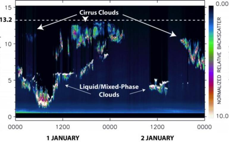
NASA lidar on Elvey Building provides cloud data
August 3, 2017
A rapidly blinking green light beam has been flickering skyward through a foot-square quartz window in the north corner of the roof of the...
Read more
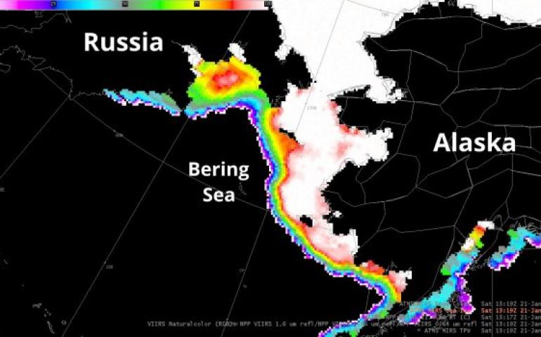
Using microwaves to see through clouds
August 3, 2017
The most common types of satellite images are only able to see the “top” of the sky — if it is a cloudy day, the satellite will only be able to...
Read more
New curriculum connects aurora, Iñupiat culture
January 26, 2017
A new curriculum that weaves aurora science with Iñupiat culture and language is now available for elementary and middle school teachers across...
Read more
NASA sounding rockets to launch from Poker Flat Research Range
January 18, 2017
A NASA sounding rocket campaign starts Jan. 20 and will run through early March at the Poker Flat Research Range in Alaska. The research rockets...
Read more
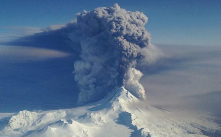
Volcano study examines relationship between seismic signals, sound waves
January 17, 2017
A study of relationships between seismic signals and sound waves from an erupting volcano in Alaska may someday help scientists infer the height...
Read more
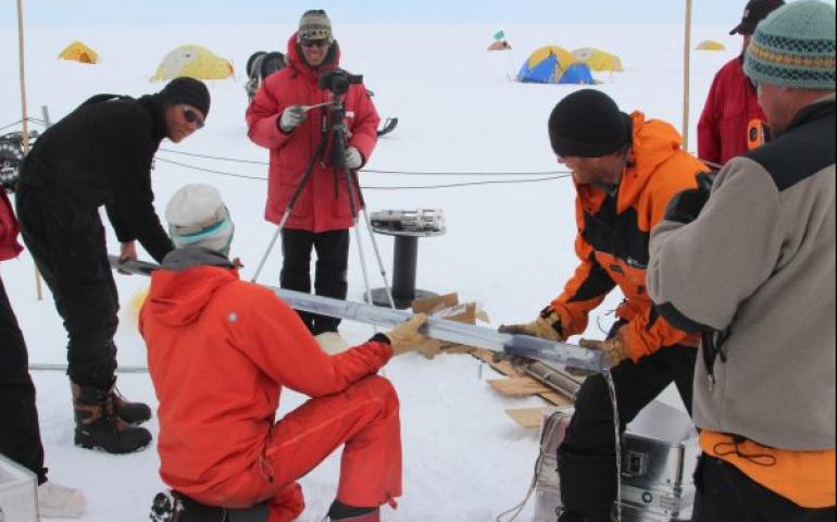
UAF researcher joins study of Arctic sea ice change
December 12, 2016
A University of Alaska Fairbanks researcher will participate in sea ice research that combines observations from unmanned aerial systems and...
Read more
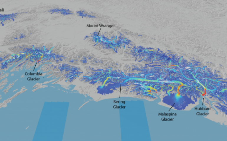
Satellite provides global view of the speed of ice
December 12, 2016
Glaciers and ice sheets move in unique and sometimes surprising patterns, as evidenced by a new capability that uses satellite images to map the...
Read more
West Antarctica’s largest glacier started retreating in 1940s
November 28, 2016
Pine Island Glacier — about the size of Florida and one of the largest ice streams in Antarctica — has been thinning and retreating at an...
Read more
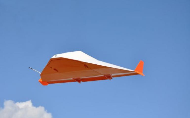
ACUASI team tests near-space glider
November 22, 2016
Staff at the University of Alaska Fairbanks helped with a successful test of a high-altitude glider to help evaluate how advanced surveillance...
Read more
Load More